
低空无人机遥感技术在公路巡检中的应用进展、挑战和前景
|
王勇,男,湖北随州人,副研究员,研究方向为低空科技、人工智能、地理大数据挖掘。E-mail: wangy@igsnrr.ac.cn |
收稿日期: 2025-05-07
修回日期: 2025-07-28
网络出版日期: 2025-09-09
基金资助
国家重点研发计划项目(2022YFC3800700)
中国科学院战略性先导(B类)科技专项(XDB0740200)
Application progress, challenges, and prospects of low-altitude UAV remote sensing technology in highway inspection
Received date: 2025-05-07
Revised date: 2025-07-28
Online published: 2025-09-09
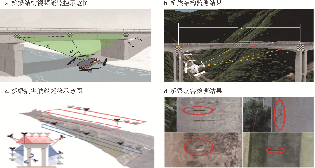
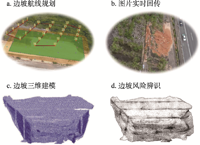
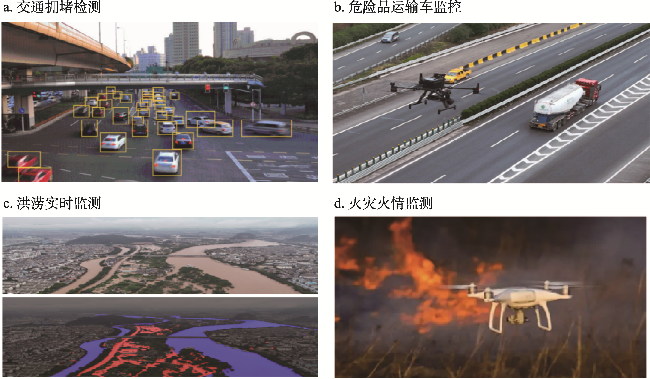
随着我国公路网建设的不断完善和交通基础设施规模的持续扩大,传统的公路巡检方式在效率、安全性和覆盖范围等方面已难以满足现代化公路管养的实际需求。低空无人机遥感技术具有机动性强、成本低、数据获取能力强等优势,为公路巡检提供了新的技术解决方案。因此,本文首先系统梳理了低空无人机遥感技术在公路巡检中的应用现状与发展趋势,深入分析了该技术在路面病害智能检测、桥梁病害识别与结构监测、边坡稳定性监测与风险预警、应急事件快速响应与灾害评估4个典型场景中的应用进展;并围绕“低空飞行—病害识别—实时计算—三维展示”的技术路径,重点探讨了低空公路巡检航线规划、路面病害自动识别、边缘端实时计算、三维重建与数字孪生等关键技术方法。其次,详细阐释了现有低空遥感技术在公路巡检应用中面临的数据稳定性与标准化不足、多源数据融合与集成应用缺乏、模型精度与行业需求不匹配、政策法规与安全管理问题等现实挑战。最后,从技术应用深度拓展、关键技术攻关突破、规范化标准化建设3个维度,提出了低空遥感技术在公路巡检领域未来发展的重点方向,为推动公路管养模式向智能化、信息化、精细化转变提供理论参考和技术支撑。
王勇 , 岑宗羲 , 何正龙 , 杨宇森 , 曾继民 , 程欣怡 , 林静 . 低空无人机遥感技术在公路巡检中的应用进展、挑战和前景[J]. 资源科学, 2025 , 47(8) : 1675 -1688 . DOI: 10.18402/resci.2025.08.06
With the continuous improvement of China’s highway network construction and the ongoing expansion of transportation infrastructure, traditional highway inspection methods can no longer meet the practical requirements of modern highway maintenance and management in terms of efficiency, safety, and coverage. Low-altitude unmanned aerial vehicle (UAV) remote sensing technology, with its advantages of high mobility, low cost, and strong data acquisition capability, provides a novel technical solution for highway inspection. Therefore, this study first systematically reviews the current application status and development trends of low-altitude UAV remote sensing technology in highway inspection, and conducts an in-depth analysis of its application progress in four typical scenarios: intelligent detection of pavement distress, bridge distress identification and vibration monitoring, slope stability monitoring and risk early warning, and rapid emergency response and disaster assessment. Focusing on the “low-altitude flight—distress identification—real-time computing—3D visualization” technical pathway, this study primarily discusses key technical methods such as low-altitude inspection route planning, automatic pavement distress identification, edge computing for real-time processing, and 3D reconstruction with digital twin. Additionally, this study elaborates on the practical challenges faced by existing low-altitude remote sensing technology in highway inspection applications, including insufficient data stability and standardization, lack of multi-source data fusion and integrated application, mismatch between model accuracy and industry requirements, and issues related to policies, regulations, and safety management. Finally, from the three dimensions of deepening technical applications, breakthroughs in key technologies, and development of standardized regulations, this study proposes the key directions for the future development of low-altitude remote sensing technology in highway inspection, providing theoretical references and technical support for advancing highway maintenance and management toward intelligent, information-based, and refined models.
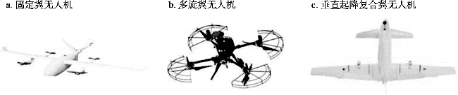
图 1 不同类型低空无人机飞行平台的外观比较Figure 1 Comparison of the appearance of different low-altitude UAV flight platforms |
表1 不同类型低空无人机飞行平台的技术特点比较Table 1 Comparison of technical characteristics among different types of low-altitude UAV flight platforms |
| 平台类型 | 飞行高度 | 飞行航时 | 场地要求 | 数据获取能力 |
|---|---|---|---|---|
| 固定翼无人机 | 可达10000 m以上 | 2~24 h | 需跑道 | 航时长、可搭载多源传感器获取大范围数据 |
| 多旋翼无人机 | 500 m以下 | 20~40 min | 垂直起降 | 可悬停、可实现精细目标物的持续采集任务 |
| 垂直起降复合翼无人机 | 2000~5000 m | 2~12 h | 垂直起降 | 兼具长航时和可悬停优势,适合中大范围精细化数据采集 |
表2 不同类型低空遥感传感器系统的特点比较Table 2 Comparison of characteristics among different types of low-altitude remote sensing sensors |
| 传感器类型 | 成像方式 | 数据特点 | 适用场景 |
|---|---|---|---|
| 光学成像传感器 | 被动成像 | 空间分辨率高、图像直观 | 路面裂缝检测、标线模糊识别 |
| 红外热成像仪 | 被动成像 | 热信息敏感、昼夜可用 | 夜间巡检、结构异常热斑检测 |
| 激光雷达 | 主动测距 | 高精度三维信息获取 | 三维建模、桥梁形变监测、边坡分析 |
表3 不同类型低空管控平台的特点比较Table 3 Comparison of characteristics among different types of low-altitude airspace management platforms |
| 平台类型 | 控制方式 | 覆盖范围 | 适用场景 |
|---|---|---|---|
| 地面控制站 | 固定式/遥控式 | 中近程 | 日常作业调度、常规飞行管理 |
| 移动指挥平台 | 便携式/车载式 | 近程 | 应急响应、野外作业、动态调度任务 |
| 云端管控系统 | 网络远程控制 | 大范围 | 多平台协同调度、远程监管与数据归档 |
| [1] |
|
| [2] |
中华人民共和国交通运输部. 2024年交通运输行业发展统计公报[N]. 中国交通报, 2025-06-12(002).
[Ministry of Transport of the People’s Republic of China. 2024 Statistical Bulletin on the Development of Transportation Industry[N]. China Transport News, 2025-06-12(002).]
|
| [3] |
|
| [4] |
|
| [5] |
|
| [6] |
|
| [7] |
|
| [8] |
|
| [9] |
|
| [10] |
王春晓, 王斐. 基于ArcEngine的公路巡检系统设计与实现[J]. 测绘科学, 2014, 39(5): 40-42.
[
|
| [11] |
|
| [12] |
付晶莹, 彭婷, 江东, 等. 草地资源立体观测研究进展与理论框架[J]. 资源科学, 2020, 42(10): 1932-1943.
[
|
| [13] |
|
| [14] |
|
| [15] |
|
| [16] |
|
| [17] |
|
| [18] |
缑永涛, 李文博, 段学锋. 基于无人机的路桥病害检测系统[J]. 测绘通报, 2022, (12): 141-146, 169.
[
|
| [19] |
|
| [20] |
|
| [21] |
|
| [22] |
|
| [23] |
|
| [24] |
|
| [25] |
|
| [26] |
|
| [27] |
|
| [28] |
|
| [29] |
余加勇, 李锋, 薛现凯, 等. 基于无人机及Mask R-CNN的桥梁结构裂缝智能识别[J]. 中国公路学报, 2021, 34(12): 80-90.
[
|
| [30] |
|
| [31] |
|
| [32] |
田雨, 王知乐, 徐俣璠, 等. 露天煤矿边坡形态参数无人机识别及安全评价[J/OL]. 采矿与安全工程学报, (2025-03-28) [2025-06-27]. https://doi.org/10.13545/j.cnki.jmse.2025.0039.
[
|
| [33] |
沈运华, 张秀荣, 刘晓煌, 等. 天空地一体化自然资源要素监测体系及其应用[J]. 资源科学, 2022, 44(8): 1696-1706.
[
|
| [34] |
|
| [35] |
|
| [36] |
|
| [37] |
廖小罕, 屈文秋, 徐晨晨, 等. 城市空中交通及其新型基础设施低空公共航路研究综述[J]. 航空学报, 2023, 44(24): 6-34.
[
|
| [38] |
|
| [39] |
|
| [40] |
|
| [41] |
|
| [42] |
|
| [43] |
张锐, 王福涛, 陈生. 高分辨率遥感在震害监测中的应用综述[J]. 遥感信息, 2024, 39(4): 1-10.
[
|
| [44] |
|
| [45] |
|
| [46] |
|
| [47] |
黄海新, 于广威, 程寿山, 等. 基于改进灰狼优化的桥梁检测爬壁机器人全覆盖路径规划[J]. 计算机应用, 2024, 44(3): 966-971.
[
|
| [48] |
刘国群, 王雨琪, 廖志刚. 基于知识抽取和强化学习的无人飞行器智能路径决策方法研究[J]. 战术导弹技术, 2024, (6): 35-44.
[
|
| [49] |
徐晨晨, 叶虎平, 岳焕印, 等. 城镇化区域无人机低空航路网迭代构建的理论体系与技术路径[J]. 地理学报, 2020, 75(5): 917-930.
[
|
| [50] |
|
| [51] |
|
| [52] |
|
| [53] |
|
| [54] |
|
| [55] |
|
| [56] |
|
| [57] |
|
| [58] |
|
| [59] |
|
| [60] |
|
| [61] |
|
| [62] |
|
| [63] |
|
| [64] |
李波, 李晗, 胡正伟. 无人机贴近摄影测量技术在建筑立面测量中的应用[J]. 测绘通报, 2024, (2): 32-36.
[
|
| [65] |
方荣辉, 杨淑群, 兰宁. 基于数字孪生的无人机巡航系统[J]. 制造业自动化, 2022, 44(11): 98-101.
[
|
| [66] |
|
| [67] |
|
| [68] |
|
| [69] |
|
| [70] |
任冬, 袁航, 张磊, 等. 大型安保任务中无人机倾斜摄影技术的三维实景建模[J]. 计算机与数字工程, 2025, 53(2): 378-383.
[
|
| [71] |
|
| [72] |
|
| [73] |
|
| [74] |
|
/
| 〈 |
|
〉 |