
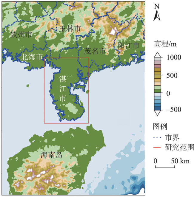
基于遥感的湛江红树林保护区生态系统时空变化特征
|
马昇鑫,男,河南镇平人,硕士研究生,研究方向为海域资源评估与海岸带管理。E-mail: shengxin1220@163.com |
收稿日期: 2022-07-31
修回日期: 2022-11-03
网络出版日期: 2023-02-25
基金资助
国家自然科学基金青年项目(42107496)
海南省院士创新平台科研专项(YSPTZX202149)
山东建筑大学博士科研基金项目(X20192Z)
Spatiotemporal characteristics of Zhanjiang Mangrove Nature Reserve ecosystem based on remote sensing
Received date: 2022-07-31
Revised date: 2022-11-03
Online published: 2023-02-25
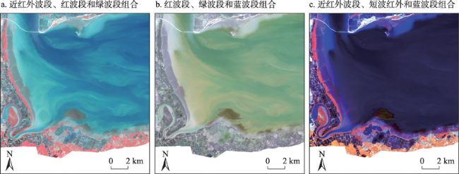
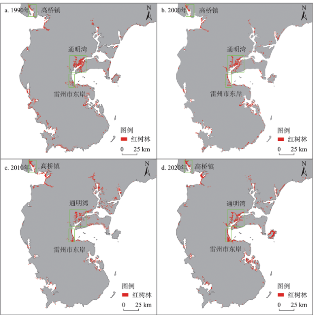
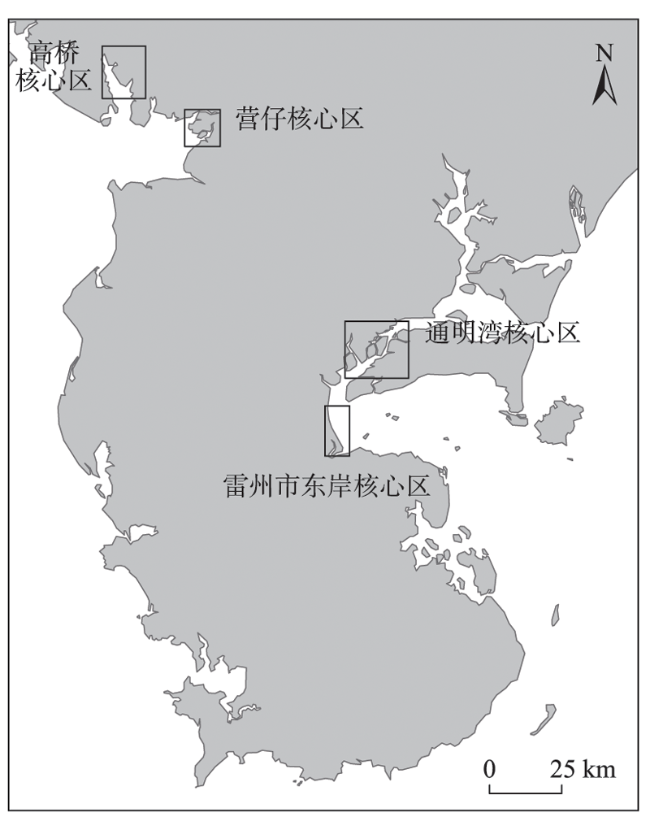
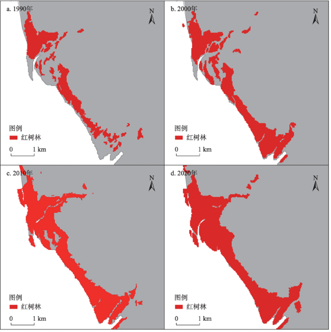
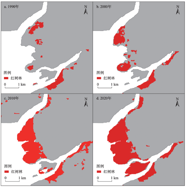
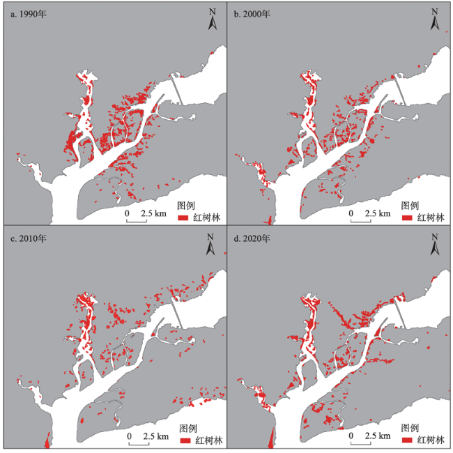
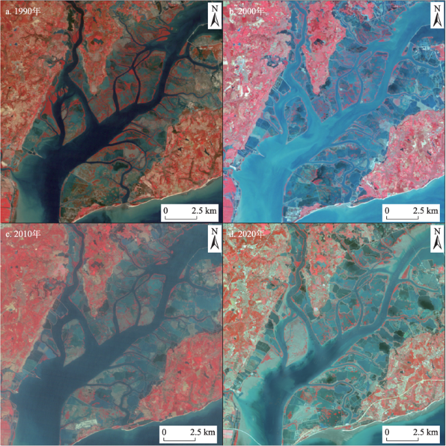
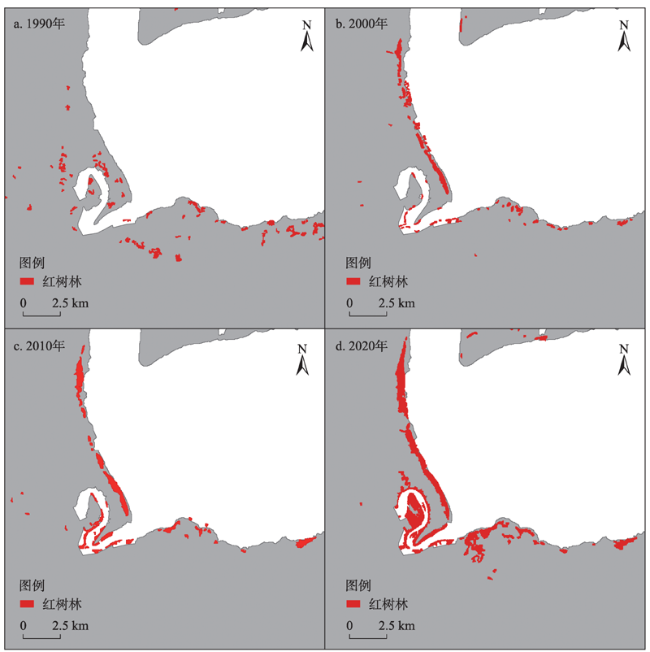
红树林是中国重要的蓝色碳汇之一,由于人为破坏导致其面积骤减,对中国蓝碳储量造成重大损失。本文使用监督分类的方法,解译了湛江红树林国家级自然保护区在1990年、2000年、2010年以及2020年4个时间节点的Landsat卫星遥感影像数据,分析了保护区红树林面积与生境破碎度等参数的动态变化及分布特征。研究发现:①湛江红树林自然保护区面积整体呈先减少后增加的变化趋势,建立保护区对红树林面积恢复有重要意义;②本文划分的4个核心区面积变化与保护区整体有所不同,其中,高桥核心区、营仔核心区和雷州市东岸核心区红树林修复取得了较好的效果,面积增长显著且破碎化程度有明显降低;而通明湾核心区由于受到水产养殖的影响,修复效果欠佳。同时,本文结合当地历史资料和文献资料分析了影响湛江红树林面积变化的主要因素,为保护区未来发展提出了相应的对策建议。
马昇鑫 , 周玲玲 , 王晋 , 余静 . 基于遥感的湛江红树林保护区生态系统时空变化特征[J]. 资源科学, 2022 , 44(12) : 2580 -2593 . DOI: 10.18402/resci.2022.12.15
Mangrove forests are one of the most important blue carbon sinks in China. The rapid decline of mangrove forests due to human destruction has caused a significant loss of China’s blue carbon reserves. In this study, we used the supervised classification method to interpret the Landsat satellite remote sensing image data of Zhanjiang Mangrove Nature Reserve in 1990, 2000, 2010, and 2020, and analyzed the dynamic changes and distribution characteristics of mangrove area and habitat fragmentation. The results show that: (1) The total area of the Zhanjiang Mangrove Nature Reserve decreased first and then increased, and the establishment of the reserve is of great significance for the restoration of mangrove area; (2) The four core areas experienced different changes in area than the overall areal change of the reserve. Among these areas, mangrove restoration of Gaoqiao core area, Yingzi core area, and Eastern Coast of Leizhou City core area achieved good results, with significant areal growth and significantly reduced degree of fragmentation, while the Tongming Bay core area was affected by aquaculture and the restoration effect was less satisfactory. The main factors affecting the change of mangrove area in Zhanjiang were analyzed based on the local historical and documentary data, and the corresponding countermeasures and recommendations were put forward for the future development of the reserve.
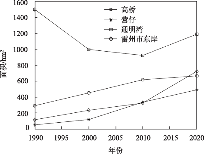
图7 1990年、2000年、2010年和2020年通明湾核心区红树林面积变化Figure 7 Change of mangrove area in the Tongming Bay core area in 1990, 2000, 2010, and 2020 |
表1 1990—2020年核心区红树林斑块数量统计Table 1 Statistical results of mangrove patch number in the core areas, 1990-2020 |
| 年份 | 高桥 | 营仔 | 通明湾 | 雷州市东岸 | 保护区整体 |
|---|---|---|---|---|---|
| 1990 | 20 | 6 | 228 | 36 | 972 |
| 2000 | 14 | 9 | 231 | 38 | 809 |
| 2010 | 11 | 4 | 202 | 29 | 834 |
| 2020 | 8 | 4 | 176 | 17 | 771 |
表2 1990—2020年红树林平均斑块面积 (hm2)Table 2 Mean area of individual patches in the mangrove forests, |
| 年份 | 高桥 | 营仔 | 通明湾 | 雷州市东岸 | 保护区整体 |
|---|---|---|---|---|---|
| 1990 | 14.83 | 9.33 | 6.61 | 3.33 | 5.30 |
| 2000 | 32.69 | 13.58 | 4.34 | 6.28 | 5.36 |
| 2010 | 56.65 | 85.10 | 4.60 | 11.40 | 6.37 |
| 2020 | 83.99 | 124.15 | 6.80 | 42.89 | 8.92 |
1990-2020 (hm2) |
| [1] |
赵晟, 洪华生, 张珞平, 等. 中国红树林生态系统服务的能值价值[J]. 资源科学, 2007, (1): 147-154.
[
|
| [2] |
|
| [3] |
黄翀. 基于时序遥感的柬埔寨水稻种植时空格局监测[J]. 资源科学, 2021, 43(12): 2393-2402.
[
|
| [4] |
|
| [5] |
|
| [6] |
|
| [7] |
|
| [8] |
|
| [9] |
|
| [10] |
贾明明, 王宗明, 毛德华, 等. 面向可持续发展目标的中国红树林近50年变化分析[J]. 科学通报, 2021, 66(30): 3886-3901.
[
|
| [11] |
|
| [12] |
|
| [13] |
|
| [14] |
|
| [15] |
|
| [16] |
刘大召, 韩泽文, 沈春燕. 1991-2011年廉江红树林分布及变化的遥感分析[J]. 海洋科学, 2019, 43(4): 22-28.
[
|
| [17] |
高常军, 蒋侠朋, 甄佳宁, 等. 耦合WorldView-2和珠海一号影像的红树林物种分布[J]. 遥感学报, 2022, 26(6): 1155-1168.
[
|
| [18] |
|
| [19] |
向爱, 揣小伟, 李家胜. 中国沿海省份蓝碳现状与能力评估[J]. 资源科学, 2022, 44(6): 1138-1154.
[
|
| [20] |
王子予, 刘凯, 彭力恒, 等. 基于Google Earth Engine的1986-2018年广东红树林年际变化遥感分析[J]. 热带地理, 2020, 40(5): 881-892.
[
|
| [21] |
湛江市人民政府. 气候特征[R/OL]. (2020-12-30) [2022-06-25]https://www. zhanjiang.gov.cn/qhtz/content/post_1202574.html.
[The people’s Government of Zhanjiang Municipality. Climatic Characteristics[R/OL]. (2020-12-30) [2022-06-25]https://www.zhanjiang.gov.cn/qhtz/content/post_1202574.html.]
|
| [22] |
李贺, 何志杰, 黄翀, 等. 2000-2019年缅甸南部橡胶林时空演变[J]. 资源科学, 2021, 43(12): 2403-2415.
[
|
| [23] |
|
| [24] |
|
| [25] |
|
| [26] |
|
| [27] |
谢亮亮. 基于遥感的广西北部湾红树林演变研究[D]. 长沙: 湖南农业大学, 2020.
[
|
| [28] |
郭晋平. 森林景观生态研究[M]. 北京: 北京大学出版社, 2001.
[
|
| [29] |
|
| [30] |
|
| [31] |
徐家雄, 林广旋, 邱焕秀, 等. 广东白骨壤群落上的广州小斑螟生物学特性及种群数量消长规律研究[J]. 广东林业科技, 2008, (3): 8-16.
[
|
| [32] |
庄鑫龙, 林晶, 李裕红. 我国东南沿海红树林虫害状况及防治[J]. 海峡科学, 2011, (7): 19-22.
[
|
| [33] |
郭欣, 潘伟生, 陈粤超, 等. 广东湛江红树林自然保护区及附近海岸互花米草入侵与红树林保护[J]. 林业与环境科学, 2018, 34(4): 58-63.
[
|
| [34] |
中华人民共和国自然资源部. 2021年中国海平面公报[R/OL]. (2022-04-08)[2022-06-25]http://gi.mnr.gov.cn/202205/t20220507_2735509.html.
[Ministry of Natural Resources of the People’s Republic of China. China Sea Level Bulletin 2021[R/OL]. (2022-04-08) [2022-06-25]http://gi.mnr.gov.cn/202205/t20220507_2735509.html.]
|
| [35] |
陈粤超. 湛江红树林保护区现状、存在问题与策略[J]. 林业科技管理, 2004, (2): 35-36.
[
|
| [36] |
王超. 湛江市海洋环境污染防治管理策略研究[D]. 南昌: 江西财经大学, 2019.
[
|
| [37] |
曹林, 韩维栋, 李凤凤, 等. 雷州湾红树湿地景观格局演变及驱动力分析[J]. 林业科技开发, 2010, 24(4): 18-23.
[
|
/
| 〈 |
|
〉 |