
Resource and environmental carrying capacity and optimal population size for village and town development: Taking Yongfeng County of Jiangxi Province as an example
Received date: 2020-05-05
Request revised date: 2020-07-05
Online published: 2020-09-25
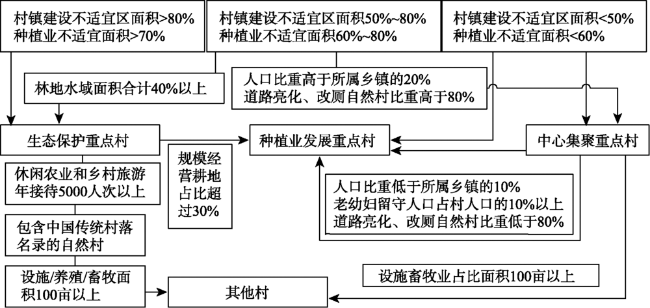
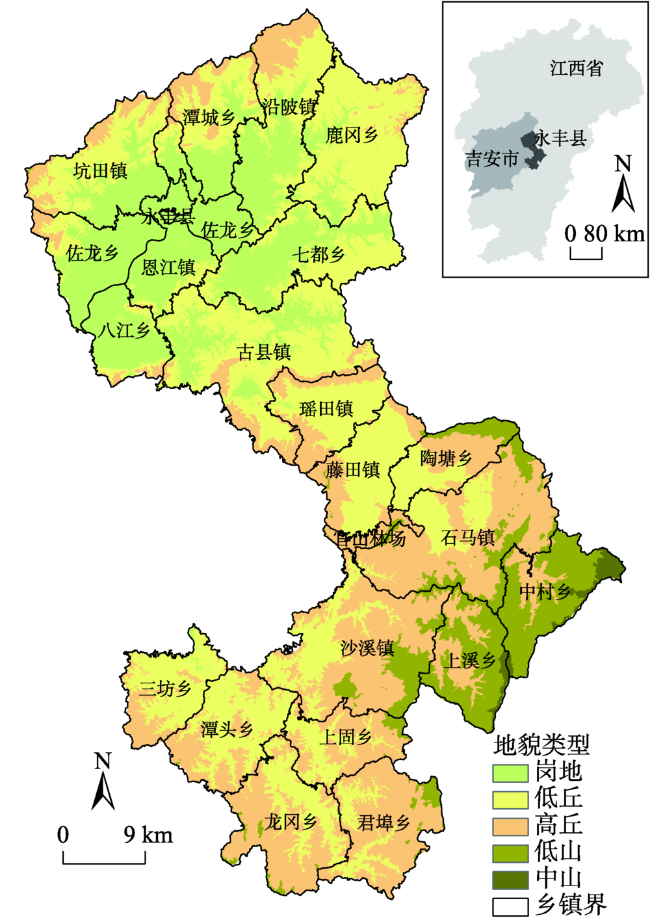
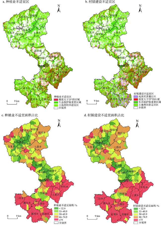
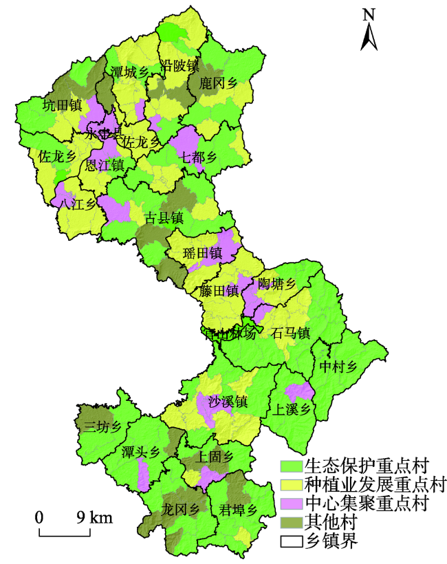
The research of resources and environmental carrying capacity is an important basic work in China’s national land use planning and rural revitalization planning. Current research on resources and environmental carrying capacity remains at large regional scale, and the evaluation of carrying capacity for villages and towns is relatively uncommon. Based on a summary of previous research, this study explored the evaluation method of resources and environmental carrying capacity for villages and towns at the county scale on the basis of the “dual evaluation” technical guideline of the National Land and Spatial Planning published by the Ministry of Natural Resources. Yongfeng County of Jiangxi Province, which is located in the hilly area south of the Yangtze River, with a total population of 44×104 in 2017, was taken as an example. Based on the preliminary evaluation of the characteristics of the village and town development in Yongfeng County and the resources and environmental constraints, the index system for determining the unsuitable areas for cropping and village and town development with land, geological hazards, and ecology as the main limiting factors was established, and administrative villages were classified. Appropriate types of village and town development for village units and optimal population size of the county were determined under two scenarios of high development intensity and average development intensity. The results of the study show that the areas unsuitable for cropping and village and town development in Yongfeng County were 1797.77 km2and 1838.68 km2, respectively, which is 1838.94 km2 excluding the overlapping area, accounting for 67.81% of the county area. According to the unsuitable area, current population, and village and town development level, the 216 administrative villages in the county can be divided into four major categories: ecological protection key villages, cropping development key villages, central key villages, and other villages. Under the scenarios of local high development intensity and average development intensity, the largest population that the county’s arable land and planting industry can support will be 135.38×10⁴ and 140.10×10⁴, respectively. Assuming 100 m2, 140 m2, and 200 m2 per capita construction land, under the high-intensity development scenario, the number of population that can be supported by villages and towns in the county will be 84.05×10⁴, 60.04×10⁴, and 42.03×10⁴ respectively; under the average development intensity scenario, the population size will be 54.61×10⁴, 39.01×10⁴, and 27.31×10⁴ respectively. The results of this research can provide a case for the current “dual evaluation” technical guideline, and provide a reference for the implementation of rural revitalization and village and town planning in Yongfeng County.
MA Dingguo , DAI Xiongzu , YANG Jinfeng , WANG Chuansheng . Resource and environmental carrying capacity and optimal population size for village and town development: Taking Yongfeng County of Jiangxi Province as an example[J]. Resources Science, 2020 , 42(7) : 1249 -1261 . DOI: 10.18402/resci.2020.07.03
表1 种植业和村镇不适宜区判定的主要指标Table 1 Main indicators for the non-suitability evaluation of cropping and village and town development |
| 区域类型 | 生态保护重要程度 | 地形 | 土地利用类型 | 灾害 |
|---|---|---|---|---|
| 种植业 | 生态保护红线区 | 坡度大于25°的区域 | 坡度大于25°的非梯田、有林地、河湖库、风景名胜地、林场 | — |
| 村镇 | 生态保护红线区 | 坡度大于25°的区域 | 有林地、河湖库、滩涂、坑塘、风景名胜地、林场 | 地质灾害高风险区 |
表2 地质灾害高风险区判定Table 2 High risk area of main geological disasters |
| 灾害类型 | 灾害点风险区等级 | 灾害点危险程度 | 灾害点预警级别 | 避让范围/m |
|---|---|---|---|---|
| 崩塌 | 高、中风险区 | 高或中 | 红或橙色 | 100 |
| 滑坡 | 高、中风险区 | 高或中 | 红或橙色 | 200 |
| 泥石流 | 所有风险区 | 高、中、低 | 红、橙、黄色 | 500 |
表3 吉安市和永丰县不同功能类型区建设用地和耕地占土地面积的比例Table 3 Proportion of cultivated land and construction land in various main functional zones of Ji’an City and Yongfeng County |
| 地区类型 | 地名 | 耕地 占比/% | 建设用地 占比/% |
|---|---|---|---|
| 重点开发区 | 吉州区 | 0.37 | 0.17 |
| 重点开发区(县) | 吉安县 | 0.25 | 0.06 |
| 农产品主产区(县) | 泰和县 | 0.23 | 0.04 |
| 农产品主产区(县) | 新干县 | 0.30 | 0.06 |
| 农产品主产区(县) | 永丰县 | 0.18 | 0.04 |
| 县城(乡镇) | 永丰县恩江镇 | 0.27 | 0.23 |
| 农业型(乡镇) | 永丰县藤田镇 | 0.35 | 0.06 |
| 生态型(乡镇) | 永丰县君埠乡 | 0.10 | 0.02 |
表4 4种类型村镇的开发强度控制系数Table 4 Development intensity control coefficients of four types of villages and towns |
| 项目 | 生态保护 重点村 | 种植业发展 重点村 | 中心集聚 重点村 | 其他村 |
|---|---|---|---|---|
| 高强度情景 | 0.02 | 0.10 | 0.23 | 0.03 |
| 平均强度情景 | 0.02 | 0.06 | 0.15 | 0.02 |
表5 各类村庄适宜面积统计Table 5 Suitable area for various villages |
| 项目 | 生态保护重点村 | 种植业发展重点村 | 中心集聚重点村 | 其他村 | 核计 | |
|---|---|---|---|---|---|---|
| 行政村数/个 | 85 | 84 | 30 | 17 | 216 | |
| 总面积/km2 | 1327.29 | 833.82 | 241.20 | 309.64 | 2711.95 | |
| 评价面积/km2 | 282.06 | 422.10 | 147.10 | 78.97 | 930.23 | |
| 种植业面积/km2 | 高强度情景 | 276.42 | 379.89 | 113.27 | 76.60 | 846.18 |
| 平均强度情景 | 276.42 | 396.77 | 125.04 | 77.39 | 875.62 | |
| 村镇建设面积/km2 | 高强度情景 | 5.64 | 42.21 | 33.83 | 2.37 | 84.05 |
| 平均强度情景 | 5.64 | 25.33 | 22.07 | 1.58 | 54.61 | |
表6 基于种植业适宜面积的人口规模概算Table 6 Estimated population size based on suitable area for cropping |
| 情景 | 最大可用面积/hm2 | 耕地粮食单产/(kg/hm2) | 粮食需求/(kg/(人·年)) | 潜在最大承载人口/万人 | 现状人口/万人 |
|---|---|---|---|---|---|
| 高强度情景 | 84617.67 | 7200 | 450 | 135.38 | 44 |
| 平均强度情景 | 87561.84 | 140.10 |
表7 基于村镇建设适宜面积的人口规模概算Table 7 Estimated population size based on the suitable area for village and town development |
| 情景 | 最大可用面积/km2 | 人均建设用地指标/m2 | 最大承载人口/万人 | 现状人口/万人 | 现状城镇化率/% |
|---|---|---|---|---|---|
| 高强度情景 | 84.05 | 100 | 84.05 | 44 | 45 |
| 140 | 60.04 | ||||
| 200 | 42.03 | ||||
| 平均强度情景 | 54.61 | 100 | 54.61 | ||
| 140 | 39.01 | ||||
| 200 | 27.31 |
| [1] |
马凯. 中华人民共和国国民经济和社会发展第十一个五年规划纲要辅导读本[M]. 北京: 北京科学技术出版社, 2006.
[
|
| [2] |
国务院发展研究中心课题组. 主体功能区形成机制和分类管理政策研究[M]. 北京: 中国发展出版社, 2008.
[ Research Group of the Development Research Center of the State Council. A Study on the Mechanism and Policies for the Formation of Development Priority Zones[M]. Beijing: China Development Press, 2008.]
|
| [3] |
樊杰. 我国主体功能区划的科学基础[J]. 地理学报, 2007,62(4):339-350.
[
|
| [4] |
樊杰, 王亚飞, 汤青, 等. 全国资源环境承载能力监测预警(2014 版)学术思路与总体技术流程[J]. 地理科学, 2015,35(1):1-10.
[
|
| [5] |
刘坤. 国家发改委: 推动资源环境承载能力监测预警规范化常态化制度化[N]. 光明日报, 2017-09-23(02).
[
|
| [6] |
郝庆, 邓玲, 封志明. 国土空间规划中的承载力反思: 概念、理论与实践[J]. 自然资源学报, 2019,34(10):2073-2086.
[
|
| [7] |
中共中央国务院印发《乡村振兴战略规划(2018-2022年)》[J]. 农村工作通讯, 2018, (18):8-35.
[ The State Council of the Communist Party of China issued 《The Strategic Plan for Rural Revitalization (2018-2022)》[J]. Rural Work Newsletter, 2018, (18):8-35.]
|
| [8] |
陈明星, 龙花楼, 王成金, 等. 我国人文与经济地理学发展回顾与展望: 变化大背景下我国人文与经济地理学发展高层论坛综述[J]. 地理学报, 2016,71(8):1456-1471.
[
|
| [9] |
陈明星, 梁龙武, 王振波, 等. 美丽中国与国土空间规划关系的地理学思考[J]. 地理学报, 2019,74(12):2467-2481.
[
|
| [10] |
|
| [11] |
|
| [12] |
|
| [13] |
封志明. 土地承载力研究的过去、现在与未来[J]. 中国土地科学, 1994,8(3):1-9.
[
|
| [14] |
陈百明. 中国土地资源的人口承载能力[J]. 中国科学院院刊, 1988, (3):260-267.
[
|
| [15] |
郑振源. 中国土地的人口承载潜力研究[J]. 中国土地科学, 1996,10(5):32-35.
[
|
| [16] |
封志明, 杨艳昭, 张晶. 中国基于人粮关系的土地资源承载力研究: 从分县到全国[J]. 自然资源学报, 2008,23(5):865-875.
[
|
| [17] |
封志明, 杨艳昭, 游珍. 中国人口分布的土地资源限制性和限制度研究[J]. 地理研究, 2014,33(8):1395-1405.
[
|
| [18] |
封志明, 杨艳昭, 游珍. 中国人口分布的水资源限制性与限制度研究[J]. 自然资源学报, 2014,29(10):1637-1648.
[
|
| [19] |
毛汉英, 余丹林. 环渤海地区区域承载力研究[J]. 地理学报, 2001,56(3):363-371.
[
|
| [20] |
余丹林, 毛汉英, 高群. 状态空间衡量区域承载状况初探: 以环渤海地区为例[J]. 地理研究, 2003,22(2):201-210.
[
|
| [21] |
樊杰. 京津冀都市圈区域综合规划研究[M]. 北京: 科学出版社, 2008.
[
|
| [22] |
樊杰, 周成虎, 顾行发, 等. 国家汶川地震灾后重建规划: 资源环境承载能力评价[M]. 北京: 科学出版社, 2009.
[
|
| [23] |
封志明, 杨艳昭, 闫慧敏, 等. 百年来的资源环境承载力研究: 从理论到实践[J]. 资源科学, 2017,39(3):379-395.
[
|
| [24] |
樊杰. 资源环境承载能力与国土空间开发适宜性评价[M]. 北京: 科学出版社, 2019.
[
|
| [25] |
曹智, 刘彦随, 李裕瑞, 等. 中国专业村镇空间格局及其影响因素[J]. 地理学报, 2020,75(8):1647-1666.
[
|
| [26] |
李裕瑞, 卜长利, 曹智, 等. 面向乡村振兴战略的村庄分类方法与实证研究[J]. 自然资源学报, 2020,35(2):243-256.
[
|
| [27] |
周侃, 樊杰, 盛科荣. 国土空间管控的方法与途径[J]. 地理研究, 2019,38(10):2527-2540.
[
|
| [28] |
刘毅, 周成虎, 王传胜, 等. 长江经济带建设的若干问题与建议[J]. 地理科学进展, 2015,34(11):1345-1355.
[
|
| [29] |
程鹏飞. 中国地理国情蓝皮书(2017版)[M]. 北京: 中国测绘出版社, 2017.
[
|
| [30] |
中华人民共和国建设部, 中华人民共和国国家质量监督检验检疫总局. 镇规划标准(GB50188-2007)[M]. 北京: 中国建筑工业出版社, 2007.
[ Ministry of Construction of the People’s Republic of China, General Administration of Quality Supervision, Inspection and Quarantine of the People’s Republic of China. Town Planning Standards (GB50188-2007)[M]. Beijing: China Building Industry Press, 2007.]
|
| [31] |
孙侦, 贾绍凤, 严家宝, 等. 中国水土资源本底匹配状况研究[J]. 自然资源学报, 2018,33(12):2057-2066.
[
|
| [32] |
陈飞, 徐翔宇, 羊艳, 等. 中国地下水资源演变趋势及影响因素分析[J/OL]. 水科学进展, (2020-07-02)[2020-07-05]. https://kns.cnki.net/kcms/detail/32.1309.P.20200702.1151.004.html.
[
|
| [33] |
牛方曲, 封志明, 刘慧. 资源环境承载力评价方法回顾与展望[J]. 资源科学, 2018,40(4):655-663.
[
|
| [34] |
封志明, 李鹏. 承载力概念的源起与发展: 基于资源环境视角的讨论[J]. 自然资源学报, 2018,33(9):1475-1489.
[
|
| [35] |
|
/
| 〈 |
|
〉 |