
Research on monitoring and early warning of land and water resources carrying capacity in the Tibet Autonomous Region
Received date: 2017-10-15
Request revised date: 2018-04-04
Online published: 2018-06-22
Copyright
Water and land resources are indispensable natural resources, whose carrying capacity for economic and social development is an important measure of the degree of coordination between society, land and regional sustainable development. Research on the surveillance and warning of water-land resources carrying capacity provides technical support for controlling regional resource environmental pressures. Under the case study of Tibet, taking into account resource, environmental and ecological attributes, we select key indicators to build a monitoring and early warning index system of regional water and land resources carrying capacity. The system includes water resources, water environment, productive land and ecological land. Based on international, national and industry standards, regulations and research, the key thresholds for different indicators are determined. We divided three warning levels into high to low as red, orange and yellow. From 2005 to 2014, using analytic hierarchy processes and expert scoring of the index system we found that indicators such as water quality compliance rate, per capita grain yield, per capita arable land area and grassland degradation degree significantly impact the regional water resource carrying capacity. Land resources need to be strengthened. The comprehensive carrying capacity of regional water and land resources has increased. The orange warning interval has down to the blue warning interval, meaning that regional water and land resources have improved.
GAO Jie , LIU Yujie , FENG Zhiming , PAN Tao , YANG Yanzhao , ZHANG Hao . Research on monitoring and early warning of land and water resources carrying capacity in the Tibet Autonomous Region[J]. Resources Science, 2018 , 40(6) : 1209 -1221 . DOI: 10.18402/resci.2018.06.11
Table 1 Monitoring indexes system of water and land resources carrying capacity in Tibet Autonomous Region表1 西藏自治区水土资源承载力监测预警指标体系 |
| 目标层 | 准则层 | 要素层 | 指标层 | 指标意义 | 数据来源/计算方法 |
|---|---|---|---|---|---|
| 水土资源承载力监测预警指标 | 水资源承载力监测预警指标 | 水资源承载力监测预警 | 人均水资源占有量 | 反映区域人均水资源占有量 | 水资源总量/区域常住人口 |
| 区域用水总量 | 反映区域水资源利用量 | 来源于《西藏水资源公报》[30] | |||
| 万元工业增加值耗水 | 反映区域工业用水效率 | 工业取水总量/工业增加值 | |||
| 万元GDP耗水 | 反映区域水资源利用效率 | 区域用水总量/地区生产总值 | |||
| 水环境承载力监测预警 | 水功能区水质达标率 | 反映区域水资源质量 | 来源于《西藏水资源公报》[30] | ||
| 土地资源承载力监测预警指标 | 生产性用地监测预警 | 人均粮食产量 | 反映区域人均粮食占有量 | 区域粮食总产量/区域常住人口 | |
| 人均耕地面积 | 反映区域耕地压力及人均耕地面积 | 区域耕地面积/区域常住人口 | |||
| 草畜平衡指数 | 反映区域草地合理载畜量与实际承载量之间的关系 | (草地实际载畜量-合理载畜量)/草地合理载畜量 | |||
| 城市人均建设用地 数量 | 反映区域人均建设用地面积 | 城市建设用地面积/区域常住人口 | |||
| 生态用地监测预警 | 草地退化程度 | 反映区域草地质量 | 利用NDVI计算 | ||
| 生态用地占比 | 反映区域生态用地的面积和占有量 | 生态用地(林地、草地、水域)面积/区域国土总面积 |
Table 2 Threshold interval for monitoring and warning indexes of water and land resources carrying capacity in Tibet Autonomous Region表2 西藏自治区水土资源承载力监测预警指标阈值区间 |
| 指标层 | 黄色预警 | 橙色预警 | 红色预警 |
|---|---|---|---|
| 人均水资源占有量/m³ | [2 017,8 000) | [1 760,2 017) | <1 760 |
| 区域用水总量/亿m³ | [31,34) | [34,37) | ≥37 |
| 万元工业增加值耗水/m³ | [290,320) | [320,350) | ≥350 |
| 万元GDP耗水/m³ | [420,450) | [450,480) | ≥480 |
| 水功能区水质达标率/% | [95.5,96.0) | [95.0,95.5) | ≤95.0 |
| 人均粮食产量/kg | (350,400] | (300,350] | ≤300 |
| 人均耕地面积/m² | (850,1 000] | (700,850] | ≤700 |
| 草畜平衡指数/% | [0,20) | [20,80) | ≥80 |
| 城市人均建设用地数量/m² | [110,130) | [130,150) | ≥150 |
| 草地退化程度/% | [0,-20) | [-20,-50) | ≤-50 |
| 生态用地占比/% | [60,80) | [40,60) | <40 |
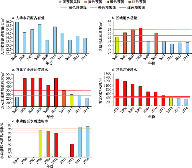
Figure 1 Dynamic change of early warning indexes of water resources carrying capacity monitoring in Tibet Autonomous Region from 2005 to 2014图1 2005—2014年西藏自治区水资源承载力监测预警指标动态变化 |
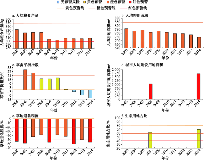
Figure 2 Dynamic change of early warning indexes of land resources carrying capacity monitoring in Tibet Autonomous Region from 2005 to 2014图2 2005—2014年西藏自治区土地资源承载力监测预警指标动态变化 |
Table 3 Responsibility of early warning indexes of comprehensive monitoring of water and land resources carrying capacity in Tibet Autonomous Region表3 西藏自治区水土资源承载力综合监测预警指标权重 |
| 水资源承载力监测预警指标 | 权重 | 土地资源承载力监测预警指标 | 权重 |
|---|---|---|---|
| 人均水资源占有量 | 0.038 5 | 人均粮食产量 | 0.057 1 |
| 区域用水总量 | 0.182 8 | 人均耕地面积 | 0.146 2 |
| 万元工业增加值耗水 | 0.078 2 | 草畜平衡指数 | 0.146 2 |
| 万元GDP耗水 | 0.078 2 | 城市人均建设用地数量 | 0.025 5 |
| 水功能区水质达标率 | 0.125 0 | 草地退化程度 | 0.093 8 |
| 生态用地占比 | 0.031 3 |
Table 4 Standard list of indicators for early warning indexes of water and land resources carrying capacity in Tibet Autonomous Region表4 西藏自治区水土资源承载力监测预警指标评分标准 |
| 指标 | 分值 | |||||
|---|---|---|---|---|---|---|
| 0 | 1 | 2 | 3 | 4 | 5 | |
| 人均水资源占有量/m³ | <1 760 | [1 760,2 000) | [2 000,4 000) | [4 000,6 000) | [6 000,8 000) | ≥8 000 |
| 区域用水总量/亿m³ | >37 | [37,35) | [35,33) | [33,31) | [31,30) | ≤30 |
| 万元工业增加值耗水/m³ | >350 | [350,325) | [325,300) | [300,275) | [275,250) | ≤250 |
| 万元GDP耗水/m³ | >480 | [480,450) | [450,420) | [420,390) | [390,360) | ≤360 |
| 水功能区水质达标率/% | <95.0 | [95.0,95.5) | [95.5,96.0) | [96.0,96.5) | [96.5,97.0) | ≥97.0 |
| 人均粮食产量/kg | <300 | [300,350) | [350,400) | [400,450) | [450,500) | ≥500 |
| 人均耕地面积/m2 | <700 | [700,850) | [850,1 000) | [1 000,1 150) | [1 150,1 300) | ≥1 300 |
| 草畜平衡指数/% | >80 | [80,60) | [60,40) | [40,20) | [20,0) | ≤0 |
| 城市人均建设用地数量/m2 | >1 500 | [1 500,1 000) | [1 000,500) | [500,200) | [200,150) | ≤150 |
| 草地退化程度/% | <-50 | [-50,-30) | [-30,-10) | [-10,10) | [10,30) | ≥30 |
| 生态用地占比/% | <40.0 | [40.0,50.0) | [50.0,60.0) | [60.0,70.0) | [70.0,80.0) | ≥80.0 |
Table 5 Standardization of early warning indicators for comprehensive monitoring of land and water carrying capacity of Tibet Autonomous Region from 2005 to 2014表5 2005—2014年西藏自治区水土资源承载力综合监测预警指标标准化结果 |
| 年份 | 人均水资源占有量 | 区域用水总量 | 万元工业增加值耗水 | 万元GDP耗水 | 水功能区水质达标率 | 人均粮食产量 | 人均耕地面积 | 草畜平衡指数 | 城市人均建设用地数量 | 草地退化程度 | 生态用地占比 |
|---|---|---|---|---|---|---|---|---|---|---|---|
| 2005 | 0.192 5 | 0.365 6 | 0.312 8 | 0 | 0.250 | 0.057 1 | 0.146 2 | 0.438 6 | 0.025 50 | 0 | 0.093 9 |
| 2006 | 0.192 5 | 0.182 8 | 0 | 0 | 0.250 | 0.057 1 | 0.146 2 | 0.438 6 | 0.025 50 | 0 | 0.093 9 |
| 2007 | 0.192 5 | 0.182 8 | 0 | 0 | 0.250 | 0.057 1 | 0.146 2 | 0.438 6 | 0.025 50 | 0.093 8 | 0.093 9 |
| 2008 | 0.192 5 | 0 | 0 | 0 | 0.250 | 0.057 1 | 0.146 2 | 0.584 8 | 0.025 50 | 0.093 8 | 0.093 9 |
| 2009 | 0.192 5 | 0.731 2 | 0 | 0 | 0.125 | 0.057 1 | 0.146 2 | 0.584 8 | 0.012 75 | 0 | 0.093 9 |
| 2010 | 0.192 5 | 0.182 8 | 0 | 0 | 0 | 0.057 1 | 0.146 2 | 0.584 8 | 0.012 75 | 0.093 8 | 0.093 9 |
| 2011 | 0.192 5 | 0.731 2 | 0.078 2 | 0 | 0 | 0.057 1 | 0.146 2 | 0.584 8 | 0.012 75 | 0.093 8 | 0.093 9 |
| 2012 | 0.192 5 | 0.914 0 | 0.234 6 | 0.156 4 | 0 | 0.057 1 | 0.146 2 | 0.731 0 | 0.012 75 | 0 | 0.125 2 |
| 2013 | 0.192 5 | 0.731 2 | 0.234 6 | 0.312 8 | 0.375 | 0.057 1 | 0.146 2 | 0.731 0 | 0.012 75 | 0.093 8 | 0.125 2 |
| 2014 | 0.192 5 | 0.731 2 | 0.312 8 | 0.391 0 | 0.500 | 0.057 1 | 0.146 2 | 0.731 0 | 0 | 0 | 0.125 2 |
Table 6 Comprehensive monitoring and pre-warning threshold of water and land resources carrying capacity in Tibet Autonomous Region表6 西藏自治区水土资源承载力综合监测预警阈值区间 |
| 标准化值 | [0,1) | [1,2) | [2,3) | [3,4) | [4,5] |
|---|---|---|---|---|---|
| 监测预警等级 | Ⅰ | Ⅱ | Ⅲ | Ⅴ | Ⅳ |
| 监测预警区间 | 红色 | 橙色 | 黄色 | 蓝色 | 绿色 |
Table 7 Water and land resources carrying capacity comprehensive monitoring and early warning results in Tibet Autonomous Region from 2005 to 2014表7 2005—2014年西藏自治区水土资源承载力综合监测预警结果 |
| 年份 | 2005 | 2006 | 2007 | 2008 | 2009 | 2010 | 2011 | 2012 | 2013 | 2014 |
|---|---|---|---|---|---|---|---|---|---|---|
| 监测预警结果 | 1.882 | 1.387 | 1.480 | 1.444 | 1.943 | 1.364 | 1.990 | 2.570 | 3.012 | 3.187 |
| 监测预警等级 | 橙色 | 橙色 | 橙色 | 橙色 | 橙色 | 橙色 | 橙色 | 黄色 | 蓝色 | 蓝色 |
The authors have declared that no competing interests exist.
| [1] |
[
|
| [2] |
国务院. 关于建立资源环境承载力监测预警长效机制的若干意见[EB/OL]. (2017-09-20)[2017-10-15].
[State Council. Several Opinions on Establishing a Long-Term Mechanism for Monitoring and Early Warning of Resources and Environmental Bearing Capacity[EB/OL]. (2017-09-20)[2017-10-15].
|
| [3] |
[
|
| [4] |
[
|
| [5] |
[
|
| [6] |
[
|
| [7] |
[
|
| [8] |
[
|
| [9] |
[
|
| [10] |
[
|
| [11] |
[
|
| [12] |
[
|
| [13] |
[
|
| [14] |
[
|
| [15] |
[
|
| [16] |
[
|
| [17] |
[
|
| [18] |
[
|
| [19] |
[
|
| [20] |
[
|
| [21] |
[
|
| [22] |
[
|
| [23] |
[
|
| [24] |
[
|
| [25] |
[
|
| [26] |
[
|
| [27] |
西藏自治区统计局. 西藏统计年鉴 (2005-2014)[M]. 北京: 中国统计出版社, 2005-2014.
[Statistical Office of Tibet Autonomous Region. Tibet Statistical Yearbook (2005-2014)[M]. Beijing: China Statistics Press, 2005-2014.]
|
| [28] |
中华人民共和国国家统计局. 中国统计年鉴(2005-2014)[M]. 北京: 中国统计出版社, 2005-2014.
[National Bureau of Statistics of the People’s Republic of China. China Statistical Yearbook (2005-2014)[M]. Beijing: China Statistics Press, 2005-2014.]
|
| [29] |
中华人民共和国国土资源部. 中国国土资源年鉴(2005-2014)[M].北京: 中国国土资源年鉴编辑部, 2005-2014.
[Ministry of Land and Resources of the People's Republic of China. China's Land and Resources Yearbook (2005-2014)[M]. Beijing: China Land and Resources Yearbook Editorial Office, 2005-2014.]
|
| [30] |
西藏自治区水利厅. 西藏水资源公报(2005-2014)[M]. 拉萨: 西藏自治区水文水资源勘测局, 2005-2014.
[Tibet Autonomous Region Department of Water Resources. Tibet Water Resources Bulletin (2005-2014)[M]. Lasa: Tibet Autonomous Region Hydrology and Water Resources Survey Bureau, 2005-2014.]
|
| [31] |
农业部. 全国草原监测报告 2014[EB/OL].(2015-04-14)[2017-10-15].
[Department of Agriculture. National Grassland Monitoring Report 2014 [EB/OL].(2015-04-14)[2017-10-15].
|
| [32] |
|
| [33] |
[
|
| [34] |
[
|
| [35] |
[
|
| [36] |
[
|
| [37] |
西藏自治区人民政府. 实行最严格水资源管理制度考核办法[Z]. 拉萨: 西藏自治区人民政府, 2014.
[People's Government of Tibet Autonomous Region. Measures for the Implementation of the Strictest Water Resources Management System[Z]. Lasa: People's Government of Tibet Autonomous Region, 2014.]
|
| [38] |
[
|
| [39] |
[
|
| [40] |
[
|
| [41] |
[
|
| [42] |
[
|
| [43] |
[
|
| [44] |
中华人民共和国住房和城乡建设部. 城市用地分类与规划建设用地标准(GB50137-2011)[EB/OL].(2012-01-01)[2017-10-15].
[
|
| [45] |
[
|
| [46] |
[
|
| [47] |
[
|
| [48] |
[
|
/
| 〈 |
|
〉 |