
Rural settlement spatial layout optimization using network center radiation guidance for Yanba Village in Chongqing
Received date: 2017-06-14
Request revised date: 2018-04-24
Online published: 2018-05-10
Copyright
Rural spatial networks are complex networks consisting of rural settlements and linear facilities. They take rural settlements as nodes and linear facilities as the support; nodes interact within it. Rural spatial networks and node centrality are capable of identifying the key position and influence of nodes in the network, providing a theoretical reference for planning and construction of rural settlements and overall network structure optimization. Taking Yanba Village of Jiangjin district in Chongqing, we established a household and rural settlements database with spatial data links to attribute data by adopting the 3S+PRA method. We measured comprehensive quality and accessibility of rural settlements by comprehensive evaluation and grid analysis methods to determine the connection degree among rural settlements by improved potential models. Using the rural settlements in the village as nodes and the connection degree among rural residential areas are edges, we constructed a village spatial network using complex network theory to identify network center points, radiation intensity and radiation range. The results show that the village spatial network has a typical non-equilibrium hierarchical structure, small world characteristics and scale-free characteristics, and low overall connectivity. According to the radiation of the center points, a network node system consists of I, II and III center node interactions as classified. On this basis, three levels of influence from the whole to parts and individuals and three optimization and recombination patterns are constructed. These include the central village (grade I center) diffusion type, grassroots village (II Center) growth type, and scattered rural settlements (grade III node) promising type.
SU Rui , WANG Cheng . Rural settlement spatial layout optimization using network center radiation guidance for Yanba Village in Chongqing[J]. Resources Science, 2018 , 40(5) : 958 -966 . DOI: 10.18402/resci.2018.05.09
Figure 1 Land use of Yanba Village图1 燕坝村土地利用现状 |
Table 1 Evaluation index system and weight of rural settlement quality表1 农村居民点质量评价指标体系及权重 |
| 目标层 | 指标层 | 指标内容 | 权重值 |
|---|---|---|---|
| 居住 环境 | 居民点规模 | 2015年实测土地利用现状图(1:2 000)的农村居民点图斑面积/hm2 | 0.053 8 |
| 地形位 | 反映高程和坡度两项地形因子 | 0.069 0 | |
| 建筑质量 | 反映房屋质量:钢混结构=1、砖混结构=0.75、砖瓦结构=0.5、土坯结构=0.25 | 0.059 0 | |
| 区位 条件 | 平均耕作半径 | 农村居民点距离耕作地块的平均距离/km | 0.045 8 |
| 距产业园区距离 | 农村居民点距离农业、工业产业园的最近距离/km | 0.041 2 | |
| 距场镇距离 | 农村居民点距离场镇中心位置的距离/km | 0.035 9 | |
| 距学校距离 | 农村居民点距离学校(主要指幼小)的最近距离/km | 0.038 1 | |
| 距医院距离 | 农村居民点距离医院/诊所的最近距离/km | 0.033 1 | |
| 距小卖部距离 | 农村居民点距离小卖部/超市的最近距离/km | 0.052 3 | |
| 服务 体系 | 水电气通达度 | 反映水电气等通达情况:通水/通电/通气=1;通两项=2;全通=3 | 0.068 5 |
| 清洁能源使用率 | 反映清洁能源使用情况:使用沼气/太阳能/天然气/其他=1,使用项数累加 | 0.063 3 | |
| 垃圾处理数量 | 农村居民点200m范围内垃圾处理设施的配置情况/个 | 0.072 8 | |
| 健身娱乐设施 | 农村居民点200m范围内休闲娱乐设施的配置情况/个 | 0.041 5 | |
| 信息通讯费用 | 农户家庭使用电话、网络的费用/(月/元) | 0.054 1 | |
| 农户 特征 | 居民点户数 | 农村居民点内所有聚集农户的户数之和/户 | 0.032 6 |
| 劳动力人口数 | 农村居民点内劳动力人口总数/人 | 0.036 4 | |
| 受教育程度 | 农村居民点内所有人口受教育年限平均值/年 | 0.063 7 | |
| 户均年收入 | 农村居民点内农户家庭年平均收入/元 | 0.040 4 | |
| 生计来源 | 反映农户收入来源和生计方式:传统耕作、规模经营、非农经营、外出务工、其他收入 (每一种生计来源赋值为1,累加统计) | 0.046 1 | |
| 参保情况 | 反映农户购买保险的情况:商业保险、医疗保险、养老保险及其他 (每一种保险类型赋值为1,累加统计) | 0.030 6 | |
| 居住满意度 | 反映农户对于农村居民点住居的满意程度:满意=1、较满意=0.75、一般=0.5、不满意=0.25 | 0.021 8 |
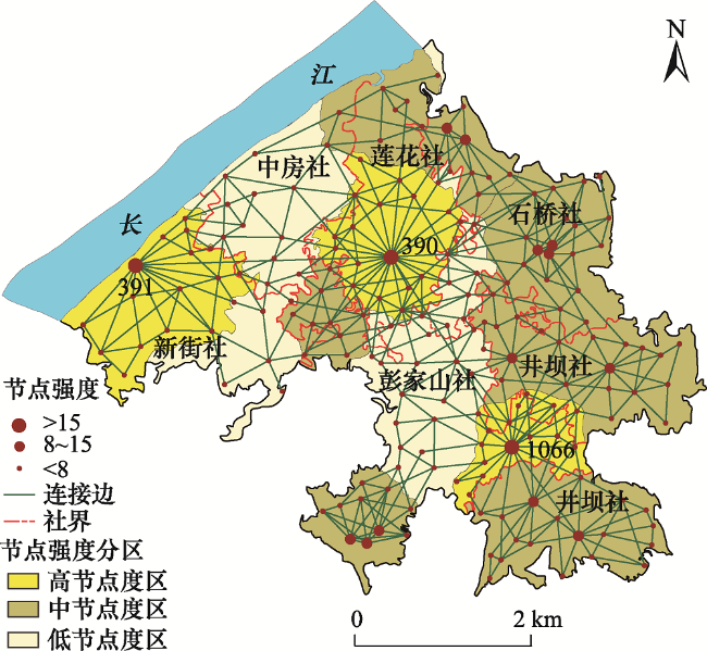
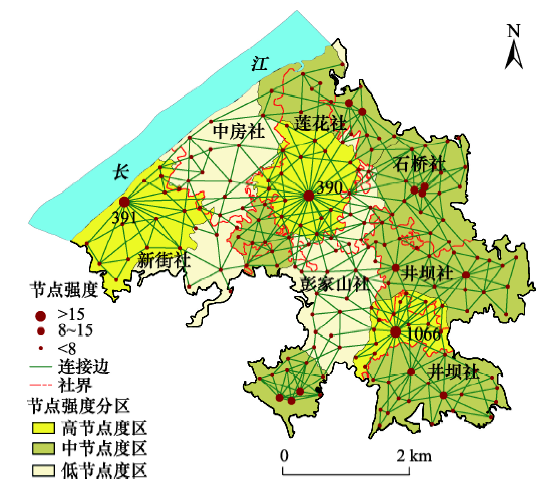
Figure 2 The village space network structure图2 村落空间网络结构 注:图中数字表示节点强度大于15的高节点。 |
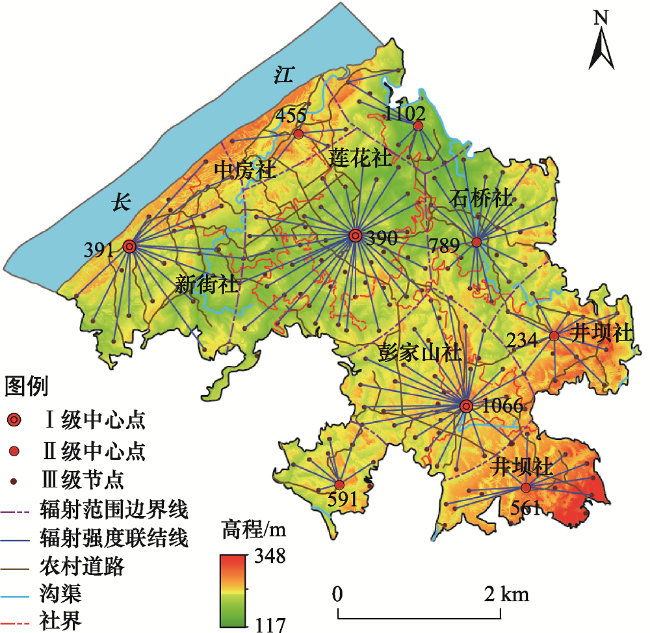
Figure 3 The village space network node system and the radiation of central point图3 村落空间网络节点体系及中心点辐射示意 注:图中数字表示Ⅰ级中心点、Ⅱ级中心点。 |
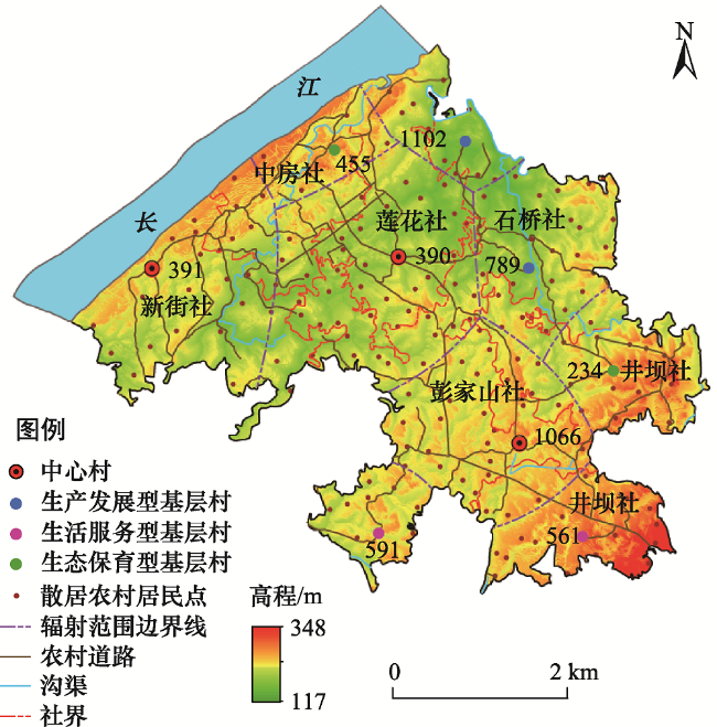
Figure 4 Recombination and optimization of rural residential land system图4 村落农村居民点体系重组与优化示意 注:图中数字表示Ⅰ级中心点、Ⅱ级中心点。 |
The authors have declared that no competing interests exist.
| [1] |
[
|
| [2] |
[
|
| [3] |
[
|
| [4] |
[
|
| [5] |
[
|
| [6] |
[
|
| [7] |
[
|
| [8] |
[
|
| [9] |
[
|
| [10] |
[
|
| [11] |
[
|
| [12] |
|
| [13] |
[
|
| [14] |
[
|
| [15] |
重庆市江津区统计信息网. 2015年重庆市江津区国民经济和社会发展统计公报[EB/OL]. (2016-02-22)[2017-06-14].
[Statistical Information Network of Jiangjin District, Chongqing. The Statistical Bulletin of the Economic and Social Development of Jiangjin District, Chongqing of the Year 2015[EB/OL]. (2016-02-22)[2017-06-14].
|
| [16] |
重庆市江津区统计信息网. 2016年重庆市江津区国民经济和社会发展统计公报[EB/OL]. (2017-07-13)[2017-11-13].
[Statistical Information Network of Jiangjin District, Chongqing. The Statistical Bulletin of the Economic and Social Development of Jiangjin District, Chongqing of the Year 2016[EB/OL]. (2017-07-13)[2017-11-13].
|
| [17] |
[
|
| [18] |
[
|
| [19] |
[
|
| [20] |
[
|
| [21] |
[
|
| [22] |
[
|
| [23] |
[
|
| [24] |
[
|
| [25] |
[
|
| [26] |
[
|
/
| 〈 |
|
〉 |