
Vertical distribution characteristics of land use in Guizhou and Guangxi Karst Mountainous region based on terrain differentiation indicators
Received date: 2017-08-23
Request revised date: 2017-09-15
Online published: 2017-10-20
Copyright
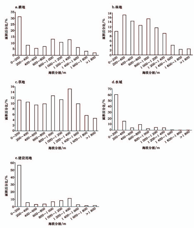
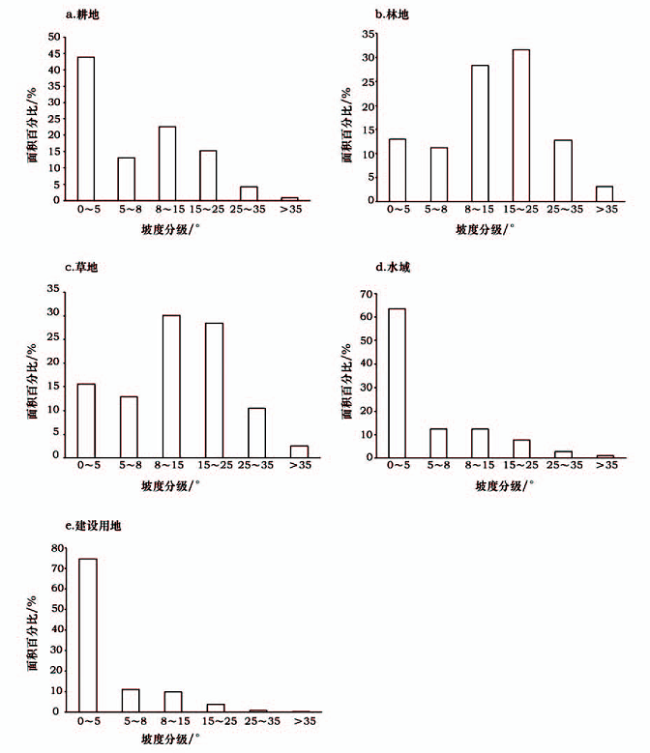
Previous studies have quantitatively characterized the relationship between land use and topographical factors using statistical terrain features of a whole study area. This does not reveal the spatial terrain distribution of land use. Based on spatial techniques,here we constructed terrain differentiation indicators,including elevation differentiation index and slope differentiation index to quantify the spatial difference of terrain gradient characteristics. Taking the Guizhou and Guangxi Karst Mountainous Region as our study area,terrain differentiation indicators were applied to explore the spatial terrain gradient characteristics of different land uses. Arable land,water body and construction land are primarily located in the low elevation area. The distribution of the forest and grassland is relatively even across different elevation classes. Arable land,water body and construction land are primarily located in low-lying areas,but steep areas are covered by forest and grassland. Using terrain differentiation indicators,it found that most of those for arable land,water body and construction land are smaller than one,indicating that these land use types tended to be located in areas with relative low altitude and slight slopes. In contrast,terrain differentiation indicators of forest and grassland were mostly larger than one,meaning that they tended to be located in areas with a high-altitude and steep slope. With increasing elevation,terrain differentiation indicators of arable land and construction land increased. This implies that the proportions of arable land and construction land located in high-altitude and steep areas increased. A higher intensity of land resource development to high-altitude and steep slope areas in counties (cities)of higher average altitude. Terrain differentiation indicators provide a quantitative method that supports the results of traditional statistical analysis and reveals local relative differences in the vertical distribution of land use.
ZHANG Hongqi , SHANG Erping , YU Zhuxiao . Vertical distribution characteristics of land use in Guizhou and Guangxi Karst Mountainous region based on terrain differentiation indicators[J]. Resources Science, 2017 , 39(10) : 1964 -1974 . DOI: 10.18402/resci.2017.10.15
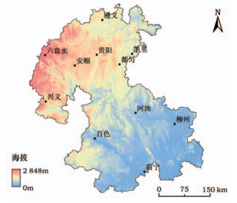
Figure 1 Location and scope of Guizhou and Guangxi Karst Mountainous Region图1 中国黔桂喀斯特山地位置和分布范围 |
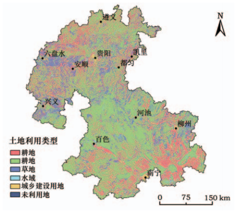
Figure 2 Land use of Guizhou and Guangxi Karst Mountainous Region in 2015图2 2015年黔桂喀斯特山地土地利用类型分布 |
Table 1 Area and proportion of land uses of Guizhou and Guangxi Karst Mountainous Region in 2015表1 2015年黔桂喀斯特山地土地利用面积及比例 |
| 耕地 | 林地 | 草地 | 水域 | 建设用地 | 未利用地 | |
|---|---|---|---|---|---|---|
| 数量/万hm2 | 551.18 | 1 218.00 | 306.85 | 22.91 | 42.18 | 0.21 |
| 比例/% | 25.74 | 56.88 | 14.33 | 1.07 | 1.97 | 0.01 |
Figure 3 Distribution of land uses of Guizhou and Guangxi Karst Mountainous Region in different elevation classes in 2015图3 2015年黔桂喀斯特山地土地利用海拔分布 |
Figure 4 Distribution of land uses of Guizhou and Guangxi Karst Mountainous Region in different slope classes in 2015图4 2015年黔桂喀斯特山地土地利用坡度分布 |
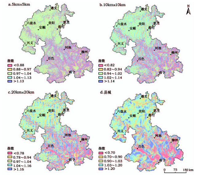
Figure 5 Elevation differentiation index of Guizhou and Guangxi Karst Mountainous Region图5 黔桂喀斯特山地海拔分异指数 |
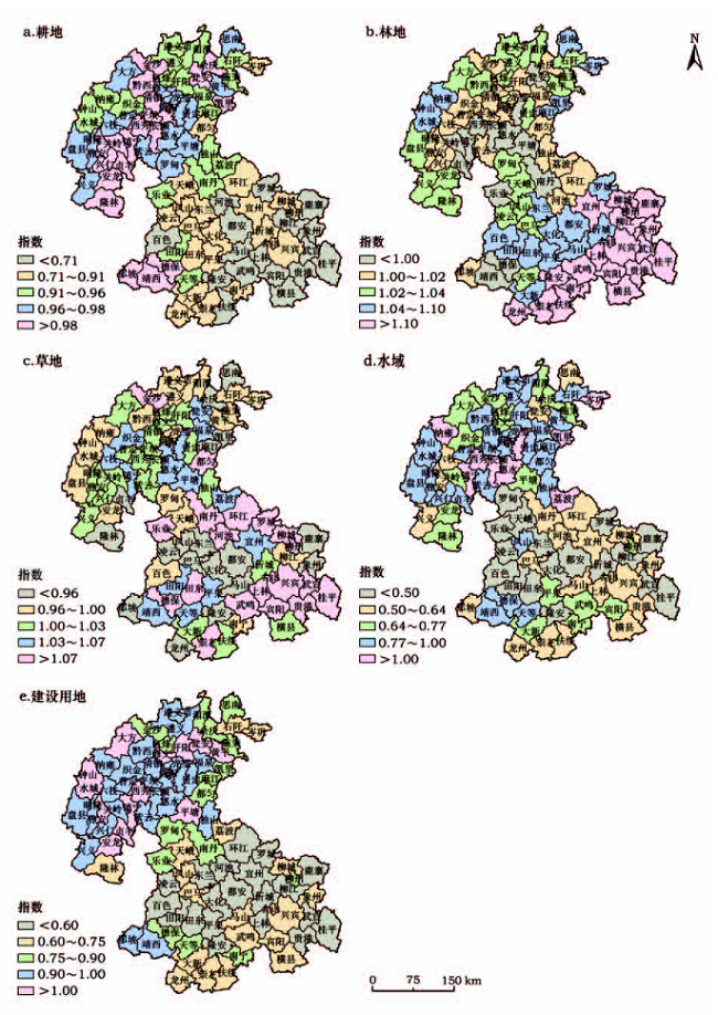
Figure 6 Mean elevation differentiation index by county unit in Guizhou and Guangxi Karst Mountainous Region图6 基于县域单元的黔桂喀斯特山地海拔分异指数 |
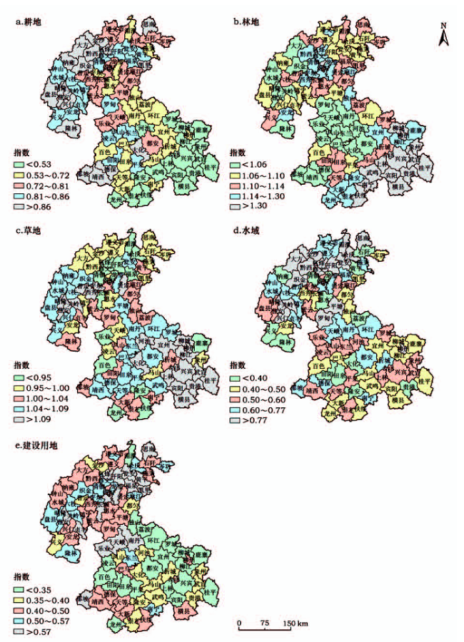
Figure 6 Mean slope differentiation index by county unit in Guizhou and Guangxi Karst Mountainous Region图7 基于县域单元的黔桂喀斯特山地坡度分异指数 |
The authors have declared that no competing interests exist.
| [1] |
|
| [2] |
|
| [3] |
[
|
| [4] |
|
| [5] |
|
| [6] |
|
| [7] |
|
| [8] |
|
| [9] |
[
|
| [10] |
[
|
| [11] |
[
|
| [12] |
|
| [13] |
[
|
| [14] |
[
|
| [15] |
[
|
| [16] |
[
|
| [17] |
[
|
| [18] |
[
|
| [19] |
[
|
| [20] |
[
|
| [21] |
[
|
| [22] |
中华人民共和国国家地图集编纂委员会. 中华人民共和国国家自然地图集[M]. 北京:中国地图出版社,1999.
[ The National Atlas Compilation Committee of the People’s Republic of China. National Natural Atlas of the People’s Republic of China[M]. Beijing:China Atlas Press,1999.]
|
| [23] |
中国科学院资源环境科学数据中心. 土地利用数据(2015)[EB/OL].[2017-09-10].
[Data Center for Resources and Environmental Sciences,Chinese Academy of Sciences. Land Use Dataset (2015)[EB/OL].[2017-09-10].
|
| [24] |
中国科学院计算机网络信息中心地理空间数据云. GDEM数据[EB/OL].[2017-09-10].
[International Scientific & Technical Data Mirror Site,Computer Network Information Center,Chinese Academy of Sciences. GDEM DEM Dataset [EB/OL].[2017-09-10].
|
/
| 〈 |
|
〉 |