
Land use patterns of the Xiongan New Area and comparison among potential choices of start zone
Received date: 2017-05-31
Request revised date: 2017-06-05
Online published: 2017-06-20
Copyright
China announced plans on 1 April 2017 to create the Xiongan New Area,a new economic zone about 110km southwest of Beijing. The new area covers the counties of Xiongxian,Rongcheng and Anxin in Hebei province,and is home to Baiyangdian,a major wetland in northern China. This is a new area of national significance. It will cover around 100km2 initially (termed as the start zone)and will be expanded to 200km2 in the mid-term and 2000km2 in the long term. It is important to reveal and analyze the land use pattern for planning and development. Based on remote sensing interpretation from Landsat OLI images,current land use features,potential of built-up land saving and intensive use,and spatial variation of arable land quality were analyzed. Three potential choices for the start zone are listed and compared. The results indicate that the proportion of arable land,built-up land and wetland are around 60%,20% and 10% respectively. The potential for rural built-up land savings and intensive use is large. The arable land quality and use intensity in Rongcheng and Anxin counties are much better than that of Xiongxian. Among three potential choices, the medium plot is the best suitable start zone. Policy recommendations on built-up land expansion,farmland saving and flood risk mitigation for the Xiongan New Area are discussed.
Key words: Xiongan New Area; land use; start zone; choice comparison; policy recommendation
JIANG Luguang , LV Peiyi , FENG Zhiming , LIU Ye . Land use patterns of the Xiongan New Area and comparison among potential choices of start zone[J]. Resources Science, 2017 , 39(6) : 991 -998 . DOI: 10.18402/resci.2017.06.01
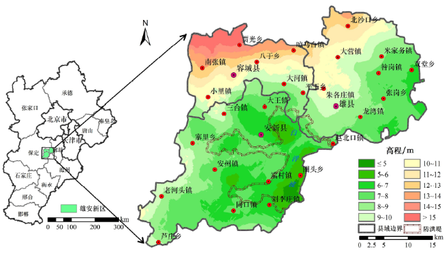
Figure 1 Location and DEM of Xiongan New Area图1 雄安新区位置、范围与高程 |
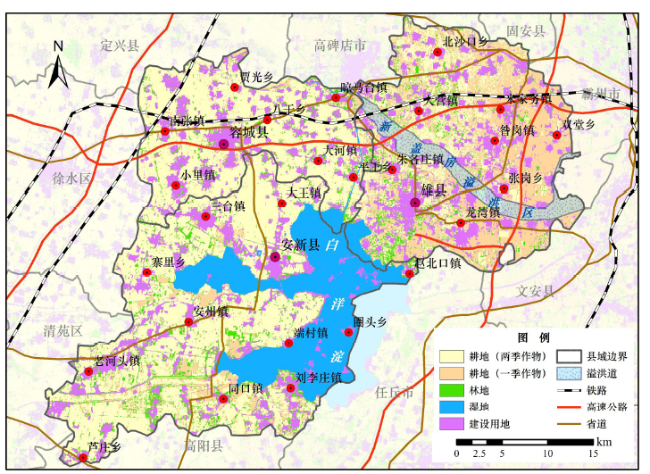
Figure 2 Land use map of Xiongan New Area in 2017图2 2017年雄安新区土地利用现状 |
Table 1 Land use structure of Xiongan New Area in 2017(hm2)表1 2017年雄安新区各类土地利用面积 |
| 区域 | 耕 地 | 建设 用地面积 | 林地面积 | 湿地面积 | 土地 总面积 | ||||
|---|---|---|---|---|---|---|---|---|---|
| 耕地面积 | 两季作物 耕地面积 | 一季作物耕地面积 | 农作物种植面积 | 复种指数 | |||||
| 雄县 | 35 800 | 11 620 | 24 180 | 47 421 | 1.32 | 12 798 | 2 880 | 970 | 52 448 |
| 容城县 | 21 660 | 19 978 | 1 682 | 41 638 | 1.92 | 7 242 | 2 058 | 591 | 31 551 |
| 安新县 | 38 355 | 33 230 | 5 126 | 71 585 | 1.87 | 11 030 | 4 820 | 17 865 | 72 070 |
| 合计 | 95 816 | 64 828 | 30 988 | 160 643 | 1.68 | 31 070 | 9 758 | 19 426 | 156 070 |
注:因白洋淀部分水面属于任丘市管辖,本表仅统计雄安新区三县范围内的湿地面积。 |
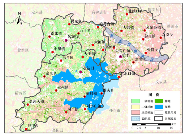
Figure 3 Arable land quanlity of Xiongan New Area图3 雄安新区耕地质量评价 |
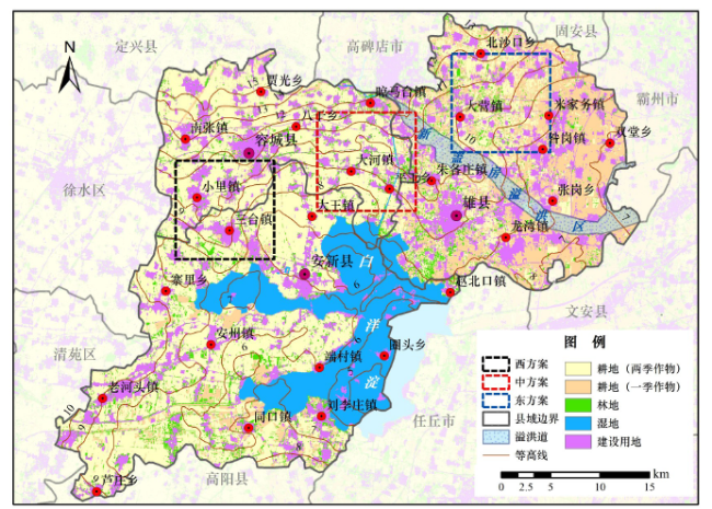
Figure 4 Comparision among potential start zones of Xiongan New Area图4 雄安新区起步区方案比选 |
Table 2 Land use indicators of three potential start zones of Xiongan New Area (hm2)表2 雄安新区起步区三个备选方案的土地指标 |
| 项目 | 耕地 | 建设用地 面积 | 林地面积 | 湿地面积 | 总面积 | ||
|---|---|---|---|---|---|---|---|
| 耕地面积 | 两季作物 耕地面积 | 一季作物 耕地面积 | |||||
| 西方案 | 6 893 | 6 267 | 626 | 2 384 | 713 | 10 | 10 000 |
| 中方案 | 6 977 | 6 098 | 879 | 2 069 | 853 | 101 | 10 000 |
| 东方案 | 6 916 | 3 493 | 3 423 | 2 249 | 830 | 5 | 10 000 |
Table 3 Comparison among three potential start zones based on key indicators表3 雄安新区起步区三个方案的主要指标评价比选 |
| 评价指标 | 西方案 | 中方案 | 东方案 |
|---|---|---|---|
| 区域完整性 | 优 | 优 | 优 |
| 未来拓展性 | 中 | 优 | 中 |
| 三县兼顾性 | 中 | 优 | 差 |
| 防洪安全性 | 中 | 中 | 中 |
| 尽量保护优质耕地 | 差 | 中 | 优 |
| 减少建设用地拆迁 | 差 | 优 | 中 |
注:针对三个备选方案和六个评价指标,分优、中、差三级进行了评价。 |
The authors have declared that no competing interests exist.
| [1] |
新华社. 中共中央、国务院决定设立河北雄安新区[EB/OL]. (2017-04-01)[2017-05-31].
[Xinhua News Agency. China to Create Xiongan New Area in Hebei[EB/OL]. (2017-04-01)[2017-05-31].
|
| [2] |
[
|
| [3] |
[
|
| [4] |
[
|
| [5] |
保定市人民政府. 保定经济统计年鉴2016[M]. 北京:中国统计出版社,2016.
[Baoding Municipal Government.Baoding Eco-nomy Statistical Yearbook 2016[M]. Beijing:China Statistics Press,2016.]
|
| [6] |
《河北省地图集》编纂委员会. 河北省地图集[M]. 北京:中国地图出版社,2011.
[Editorial Committee.Atlas of Hebei Province[M]. Beijing:China Cartographic Publishing House,2017.]
|
| [7] |
[
|
| [8] |
[
|
/
| 〈 |
|
〉 |