
This study aims to empower research on national parks by systematically reviewing the evolutionary trajectory and knowledge framework of green infrastructure research. The findings indicate that: (1) Green infrastructure is a frontier area of international research. It is a strategically planned network of natural and semi-natural areas and other environmental features, playing an increasingly prominent role in fostering a harmonious relationship between humans and nature and in promoting sustainable development. Its development has undergone four evolutionary stages: ideological emergence, conceptual formation, functional expansion, and systemic governance. (2) Empirical studies on green infrastructure mainly focus on three major themes—health and well-being, public policy, and climate adaptation—all of which are closely related to the core issues of national park conservation and development. (3) The national parks currently being established in China have become green infrastructure that safeguards ecological security and social development. Future research should address three key dimensions—multiple stakeholders, spatial scales, and service allocation—by examining issues of equity and justice in the distribution of ecosystem services between humans and non-human actors, such as flagship species and keystone vegetation. By advancing a multi-scale collaborative spatial governance approach, such research can drive theoretical and practical innovations in green infrastructure. In summary, this study reveals the profound theoretical linkages between green infrastructure and national park research, contributing to the development of China’s national park-based protected area system and fostering an inclusive vision of territorial spatial planning, while also offering Chinese insights to global ecological governance.

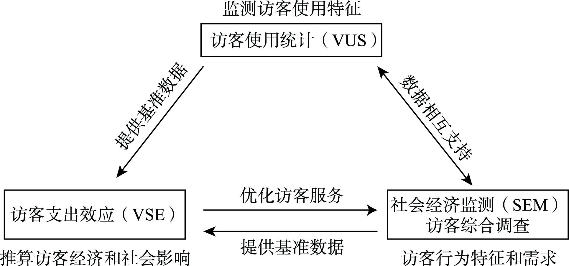
[Objective] Socioeconomic monitoring of national parks constitutes a critical basis for analyzing the relationship between national park conservation and regional high-quality development. Given the relatively short history of national park development in China, drawing lessons from the experiences of mature countries can provide valuable references for the systematic development of China’s national park socioeconomic monitoring system. [Methods] Based on various U.S. socioeconomic monitoring reports from 1979 to 2024, combined with a literature review and relevant policy analysis, this study reviews the evolution of the U.S. national park socioeconomic monitoring system. It analyzes the characteristics of major monitoring programs in terms of organizational models, monitoring content, and methods. Furthermore, it summarizes the experience of U.S. national park construction and its implications for China. [Results] The results indicate that: (1) The socioeconomic monitoring system of U.S. national parks shows a trend of continuous improvement in continuity, comprehensiveness, and standardization, and long-term, systematic, and standardized socioeconomic monitoring of national parks is conducted at a national scale. (2) Regarding the organizational model, the socioeconomic monitoring of U.S. national parks emphasizes multi-stakeholder participation and cross-sectoral collaboration. The monitoring content covers public preferences, visitor spending, and economic impacts, reflecting multi-scale characteristics. Methodologically, it achieves the standardization and systematization of indicators and analytical methods, thereby enhancing the effectiveness of data application through the dynamic nature and openness of monitoring data. [Conclusion] The U.S. national park socioeconomic monitoring system holds significant reference value for China, though it also presents limitations regarding monitoring scope, methods, and impact types. While China has preliminarily established a national park socioeconomic evaluation indicator system, a significant gap remains compared to the U.S. system. China should leverage its institutional potential and late-mover advantages to optimize the balance between conservation and utilization, strengthen multi-stakeholder engagement and regional coordination, formulate unified monitoring standards and indicators, build a dynamic and long-term monitoring system, and enhance data transparency and public participation. Wuyishan National Park can serve as a representative pilot to support the refined management of national parks in China.
Popular science tourism in geoparks plays an important role in enhancing public scientific literacy and awareness of ecological conservation. Based on 386 relevant publications from January 1999 to November 2024 at home and abroad, this study systematically reviews the research progress, constructs a core framework, and proposes directions for future research. The results show that: (1) The research trajectory of popular science tourism in geoparks can be divided into three stages: initial stage (2010 and earlier), exploratory stage (2011-2018), and development stage (after 2019). (2) The research mainly focuses on resources and products, interpretive systems, tourist motivations and perceptions, and community participation, forming a core element chain of “supply—value transmission—demand—participation”. (3) Existing studies are characterized by multiple dimensions, multiple scales, an emphasis on effectiveness, and a strong focus on experience. However, there remains room for improvement in theoretical construction, content deepening, and methodological integration, which needs further refinement. Building on the core element chain, this study further proposes a research framework for popular science tourism in China’s geoparks, aiming to develop a localized research paradigm of popular science tourism in geoparks. Additionally, it seeks to deepen the exploration of the core elements, summarize directions for future research, and thereby support the high-quality development of popular science tourism in geoparks.
[Objective] Water security is an important cornerstone of sustainable development and is closely associated with human well-being. As national parks are typical ecological functional areas, it is important to clarify the complex interaction mechanisms among their various water ecosystem services, which forms the scientific basis for achieving coordinated management of regional water security. [Methods] Based on the InVEST model, PLS-SEM model, Spearman correlation analysis and geographical detector method, this study systematically analyzed the spatiotemporal evolution characteristics and trade-offs/synergies of four key water ecosystem services (water yield, water conservation, soil retention, and water purification) in National Park of Hainan Tropical Rainforest from 2000 to 2022, identified key driving factors, and provided insights for sustainable spatial planning and management. [Results] (1) From 2000 to 2022, the overall status of three water ecosystem services—water yield, soil retention, and water conservation—in National Park of Hainan Tropical Rainforest improved, while the water purification function slightly declined. The water ecosystem services exhibited significant spatial heterogeneity, with the Wuzhi Mountain-Limuling Mountain range showing better water ecological functions than the hilly and plain areas. (2) Except for water yield and soil retention, other water ecosystem services were dominated by synergies with small fluctuations in correlation coefficients, and the synergy between water purification and water conservation was the strongest. (3) Climate change and landscape patterns directly and positively impacted all four water ecosystem services with the strongest explanatory power, while human activities showed a direct negative impact with the weakest explanatory power. [Conclusion] The water ecosystem services in National Park of Hainan Tropical Rainforest generally show an improving trend. This change is significantly influenced by the interaction between climate change and landscape patterns, while the direct impact of human activities is relatively limited. This study proposes a governance framework for water ecosystem services in national parks from four aspects: institutional construction, spatial planning, ecological management, and environmental monitoring. In the future, a theoretical framework for optimizing the water ecological security pattern should be further developed, integrating the needs of regional ecological conservation and spatial governance. This will provide important theoretical support for maintaining the integrity and stability of water ecosystems in national parks and promoting the sustainable governance of territorial space.
[Objective] Scientifically assessing the spatiotemporal evolution and spatial association between ecosystem service value and ecological risk in national parks provides an important foundation for supporting differentiated ecological management and zoned restoration.[Methods] Taking Sanjiangyuan National Park as the study area, this study utilized land cover data from 2000 to 2020 and integrated spatial autocorrelation analysis, geographically weighted regression with optimal bandwidth, random forest, and an optimal-parameter geographic detector to analyze the dynamics of different ecosystem types and to reveal the spatiotemporal evolution, spatial association, and driving mechanisms of ecosystem service value and ecological risk. [Results] (1) From 2000 to 2020, significant differences were observed in the area changes among ecosystem types in the study area, with shrubs and cropland showing the largest changes (-3.19% and -2.69%, respectively), while grassland exhibited the smallest change (-0.13%). (2) Ecosystem service value showed an overall increasing trend. The area of high-level ecosystem service value decreased the most (-2.60%), whereas the area of relatively low-level ecosystem service value increased the most (1.57%). (3) Ecological risk exhibited an overall decreasing trend. The area of high-level ecological risk decreased the most (-3.05%), while the area of moderate-level ecological risk increased the most (1.42%). (4) Ecosystem service value and ecological risk were closely spatially associated and could be classified into four spatial clustering types: high value - high risk, high value - low risk, low value - high risk, and low value - low risk. The high value - high risk area decreased by 0.50%, while the low value - high risk, low value - low risk, and high value - low risk areas increased by 1.41%, 1.11%, and 0.09%, respectively. (5) Driving factor analysis indicated that the human footprint index and precipitation seasonality were the most important individual driving factors. The interactions between NDVI and annual mean temperature, NDVI and the human footprint index, and railway - road distance and the human footprint index showed strong explanatory power, revealing a coupled driving mechanism of natural processes and human activities. [Conclusion] Based on spatial association characteristics, Sanjiangyuan National Park can be divided into ecological restoration-dominated zones, ecological protection-dominated zones, and ecological protection - restoration balanced zones. Considering the differences and transitions among these zones, differentiated ecological protection strategies—including zoned management, key area regulation, and targeted governance—should be implemented to support the scientific conservation and restoration of the national park ecosystem, enhance ecological functions, and promote high-quality and sustainable development of national parks.
[Objective] Addressing the persistent “protection versus development” dilemma in coastal wetland national parks, this study explores effective transformation pathways for ecotourism resources, aiming to construct innovative development models that balance ecological and economic benefits. [Methods] Taking Liaohekou National Park as a case study, a “space-attribute-behavior” three-dimensional analytical framework was introduced. Kernel density analysis was employed to reveal the spatial distribution pattern of 97 resource sites. A comprehensive evaluation model integrating the AHP-entropy weight method with a negative correction for ecological sensitivity was constructed to quantify the resource transformation potential. Text mining and sentiment analysis of 1337 online reviews were conducted to diagnose tourist perceptions. [Results] (1) Ecotourism resources exhibit a dual-core spatial pattern, with natural endowment being the primary determinant of tourism product maturity. (2) The resource transformation pathways are distinctly stratified, where semi-mature products are constrained by systematic barriers. (3) Tourist perceptions highlight a conflict between ecological scarcity and insufficient supporting facilities. [Conclusion] This study establishes a four-level transformation framework of “resource identification-gradient evaluation-product classification-model innovation” and proposes four corresponding development models (i.e., scenery-industry-city integration, innovative PPP, community co-management, and digital twin). This framework provides a systematic solution for the sustainable development of coastal wetland national parks by coordinating industry, technology, and governance.
[Objective] The national park system pilot is an important component of China’s ecological civilization development. Investigating its impact on newly established enterprises in the region is of great significance for achieving synergy between ecological conservation and economic development. [Methods] This study took the Wuyishan National Park pilot as its research subject. Based on the registration data of newly established enterprises in counties across Fujian Province (including counties, county-level cities, and municipal districts under prefecture-level cities) from 2000 to 2023, this study employed event study methodology, difference-in-differences, and machine learning models to reveal the impact of the national park system pilot on regional newly established enterprises and its underlying mechanisms. [Results] (1) The national park system pilot policy had a positive impact on the number of newly established enterprises at the county level. (2) Heterogeneity analysis showed that the national park system pilot had a stronger effect on the number of large enterprises than on medium, small, and micro enterprises, and a greater effect on private enterprises than on state-owned enterprises, Hong Kong-funded, Macao-funded, and Taiwan-funded enterprises, and foreign-funded enterprises. (3) Further analysis showed that the national park system pilot promoted industrial structure upgrading at the county level by attracting newly established enterprises in sectors such as culture, sports, and entertainment, accommodation and food services, and wholesale and retail trade. [Conclusion] The national park system pilot promotes the growth of the number of regional newly established enterprises, optimizes the regional industrial structure, and contributes to high-quality regional economic development. Local governments should formulate differentiated policies for enterprise development, support the development of green industries, and thereby achieve win-win coordination between ecological conservation and economic development.
[Objective] From the perspective of socio-cultural space, this study investigates the generative mechanisms of protected areas as a special type of socio-cultural space, thereby providing theoretical support for the management of human activities and cultural resources in these areas. [Methods] Building on the theory of the production of space and integrating the methodology of cultural sedimentation, this study constructed a three-layer analytical framework of “site-documentation-imagery”. Using methods including historical document verification, GIS spatial analysis, online text mining, and semi-structured interviews, this study systematically integrated multi-source, long-term data to analyze the generative mechanisms of socio-cultural space in the typical case of Wuyishan National Park. [Results] The empirical study showed that: (1) in the site layer (dominated by spatial practice), a significant vertical gradient differentiation was observed. Spiritual sites, such as sacrificial sites and academies, were highly concentrated in the low-altitude original scenic areas, while productive sites related to the tea industry and transportation extended into the high-altitude core protection zones. (2) In the documentation layer (dominated by representations of space), Neo-Confucian educational activities and tea industry practices during the Song and Ming dynasties formed areas of high-density overlap, constructing stable core narrative zones and demonstrating the diachronic sedimentation of spatial representations with social significance. (3) In the imagery layer (dominated by representational spaces), the visitors focused on iconic tourist landscapes, while local residents retained living cultural memories and emotional connections in deeper natural areas, highlighting differences in the representational spaces experienced by different groups. These results revealed the long-term process of expansion and formation of the socio-cultural space in Wuyishan National Park under the driving and embedding effects of human activities. [Conclusion] Based on empirical evidence, this study operationalizes the theory of the production of space into a “three-driver and three-layer” analytical framework, coupling the triadic dialectic of space with the three layers of “site-documentation-imagery”. This achieves the operational transformation of spatial production theory in protected areas and deepens the proposition that protected areas are “artifacts of social relations and historical environments”. The study provides a scientific basis for optimizing heritage interpretation systems in protected areas and for the coordinated governance of ecological conservation and cultural inheritance.
[Objective] This study analyzes the accessibility to various types of protected areas and their influencing factors at the national scale, aiming to provide a basis for balancing ecological conservation and development utilization in these areas. [Methods] Based on data from 3464 national-level protected areas in 2021 (national parks, national nature reserves, and national natural parks), this study used the Travel O-D Point Intelligent Query System (TIQS) and Geodetector to investigate the differences in the accessibility to national-level protected areas, their influencing factors, and the spatial relationship between accessibility and population distribution across 2846 county-level administrative divisions. [Results] (1) Accessibility to national parks and national nature reserves showed a pattern of “high in the northwest and low in the southeast”, while national natural parks showed a pattern of “high in the southeast and low in the northwest”. The accessibility to the three types of protected areas formed a spatial complementary pattern. (2) Elevation, terrain relief, and county area were the dominant factors affecting the accessibility to national parks and national nature reserves, while protected area density and elevation were the dominant factors affecting the accessibility to national natural parks. (3) The contradictions and pressures between ecological conservation and human activities faced by the three types of national-level protected areas exhibit significant differences. [Conclusion] There are notable spatial disparities and complementary relationships in accessibility among different types of national-level protected areas. Differentiated conservation and development strategies should be formulated by taking into account multiple factors such as population distribution, resource endowment, and economic development level.
[Objective] Carrying out detailed research on the material cultural resources of national cultural parks can provide strong support for standardized park construction and resource protection and development, while also offering a new model for the value assessment of material cultural resources in similar parks. [Methods] Taking 302 material cultural resources in the East Kunlun Mountains area as the research objects and 1 km grid as the research unit, spatial analysis and value evaluation methods were adopted to explore their spatial differentiation pattern, comprehensively assess the value of material cultural resources in this region, and provide a practical path for the construction of the East Kunlun Mountain Cultural Park. [Results] (1) The material cultural resources in the East Kunlun Mountain Cultural Park generally present a hierarchical pattern of “single-core agglomeration-peripheral dispersion”. The hotspots are concentrated in low-altitude areas such as Dulan County and Xinghai County in the northern foot, and the sub-hotspots form dual characteristics of “radiation dependence” and “endogenous drive”; the agglomeration of resources is prominent, which can be summarized as a “one-core and multi-belt” model, forming one high-density core area in “Xinghai County-Tongde County” and one small sub-core in northern Dulan County. (2) The average value of resource development conditions in the study area is 8.29×10⁻⁴, which is at a relatively high level overall; however, the overall levels of indicators such as resource value (average value 0.31×10⁻⁴), resource attributes (average value 0.67×10⁻⁴), natural environment conditions (average value 12.47×10⁻⁴), and social and economic conditions (average value 20.43×10⁻⁴) are all in the median area. (3) There are significant differences in the comprehensive value of material cultural resources between the northern and southern foots of the study area, showing a spatial differentiation pattern where the northern foot is relatively higher than the alpine area in the southern foot, and the overall value is at the median level. [Conclusion] The overall resource development conditions in the study area are good, but the intrinsic value of the resource itself (resource value, resource attributes) and the external supporting conditions (natural environment conditions, social and economic conditions) are both at a medium level, with significant spatial differentiation. Based on this result, it is suggested to construct a heritage corridor system of “one core, two wings and five nodes”, establish multi-functional cultural areas, implement a multi-element combined development strategy, and take multi-dimensional measures to promote the protection of material cultural resources and the construction of cultural parks.
[Objective] Tourism functions not only serve as an important pathway for promoting the realization of national parks’ public welfare objectives, but also represent one of the key links in achieving the synergy between ecological conservation and sustainable development. From the perspective of online travel videos, this study explores the pathways through which perceptions of cultural ecosystem services (CES) in national parks impact potential tourists’ travel intention, thereby providing theoretical and empirical references for further refined management of national park ecosystems. [Methods] Taking China’s five officially established national parks as case studies, online travel videos of national park tourism from 2015 to 2024 were screened on mainstream video-sharing platforms, and typical interaction moments between video footage and viewers’ comments were systematically extracted. Furthermore, this study employed grounded theory to investigate potential tourists’ perceptions of CES in national parks, and, based on this, analyzed their travel intention using the fuzzy-set qualitative comparative analysis (fsQCA) method. [Results] (1) From the perspective of online travel videos, perceptions of CES in national parks involved five dimensions: sensory-aesthetic experience, recreational and entertainment experience, knowledge and educational experience, sense of place and cultural identity, and national park identity. (2) The potential travel intention expressed by video viewers mainly followed five pathways: sensory immersion-driven, entertainment interaction-driven, educational identity-driven, cultural identity-driven, and ecological responsibility-driven. (3) The potential travel intention expressed by viewers was essentially a psychological process jointly driven by cognitive construction and emotional experience. Through interactive participation, it triggered the viewers’ cognitive and emotional value identification with CES of specific national parks, thereby ultimately forming travel motivation. [Conclusion] Online travel videos can effectively overcome spatiotemporal limitations and extend the benefit boundaries of CES in national parks. Potential tourists’ travel intention follows a synergistic driving mechanism of emotional experience and cognitive construction. Future new media communication for national parks should strengthen the deep integration of emotional resonance and value identification, thereby promoting the realization of public welfare objectives.
[Objective] Flagship species, as the most communicative ecological symbols of national parks, are important media for conveying the values of ecological civilization and shaping the national ecological image. This study aims to explore the influence mechanisms of flagship species promotion in national parks on public perception of the national ecological image and tourists’ behavioral intention. [Methods] Based on the cultivation theory and the cognition-affect-conation pattern, this study constructed a “communication contact-cognitive input-emotional response-behavioral output” model. Using the Giant Panda National Park as the case study and the giant panda as the flagship species for promotion, data were collected via an online questionnaire from April to May 2025 to test the research hypothesis. [Results] (1) Compared with publicity without flagship species, the promotion of flagship species in national parks could significantly and positively enhance the public perception of the national ecological image. (2) Perception of the national ecological image could significantly affect tourists’ behavioral intention, with emotional connection playing a notable mediating role between perception of the national ecological image and tourists’ behavioral intention. (3) Anthropocentric values weakened the positive impact of national ecological image perception on travel intention. [Conclusion] Flagship species promotion in national parks significantly enhances public perception of the national ecological image, which can directly enhance the public’s willingness to travel to national parks and indirectly enhance their willingness to travel through the intermediary of emotional connection. Therefore, some national parks can develop core flagship species and promote them, and on this basis, further strengthen individuals’ emotional connection, so as to promote the national ecological image in a way that appeals to emotion. Additionally, efforts should focus on cultivating values that transcend anthropocentrism, thereby laying a sustainable value foundation for continuous advancement of ecological civilization.
[Objective] Community residents’ pro-environmental willingness is a core element of national park ecological governance and plays a pivotal role in promoting the coordination between ecological conservation and community development in national parks. From a configurational perspective, this study investigates the formation pathways of pro-environmental willingness among community residents of the Northeast Tiger and Leopard National Park, thereby providing a reference for constructing a multi-stakeholder collaborative governance model for national parks. [Methods] Focusing on community residents of the Northeast Tiger and Leopard National Park, this study constructed an analytical framework of “cognitive perceptions—affective factors—external context” based on the theory of planned behavior, and applied fuzzy-set qualitative comparative analysis to identify the formation pathways of high and non-high levels of pro-environmental willingness. Furthermore, it analyzed the differences in the formation mechanisms of high-level pro-environmental willingness between the private and public spheres, and interpreted the results of the configurational analysis using inductive qualitative content analysis. [Results] (1) Awe is a necessary single condition influencing high-level pro-environmental willingness among community residents, and high-level pro-environmental willingness can be categorized into two configurational types: the endogenous emotion-cognition-driven type and exogenous norm-regulation-driven type. (2) The configurational pathways of non-high-level pro-environmental willingness among community residents are characterized by the combined absence of behavioral attitude, subjective norm, environmental regulation, and awe. (3) In the private sphere, the formation of high-level pro-environmental willingness is based on awe as a foundational core condition and jointly driven by multiple conditions, such as behavioral attitudes, perceived behavioral control, and environmental regulation. In the public sphere, the formation of such willingness requires internal motivation from behavioral attitude and awe, as well as enabling support from perceived behavioral control and environmental regulation. [Conclusion] The pro-environmental willingness of residents in national park communities is the result of a multifaceted interaction of cognitive, emotional, and external factors. To enhance this willingness, it is crucial to adhere to principles such as prioritizing essential conditions, accommodating heterogeneity, distinguishing between public and private spheres, and promoting multi-factor coordination. This approach will transform governance models to be more contextually adaptive.
[Objective] Tourism development in national parks can reshape community livelihood transitions and conservation outcomes, which is critical for local development and for achieving conservation goals. Therefore, it is of practical significance to examine how residents’ perceived tourism benefits can be effectively translated into ecological conservation behaviors. [Methods] This study draws on semi-structured interview data collected in Hubei’s Shennongjia National Park during 2022-2023 and 542 resident survey questionnaires. Using directed content analysis and partial least squares structural equation modeling (PLS-SEM), and grounded in social exchange theory, the study examines the mechanisms through which residents’ multidimensional perceived tourism benefits shape ecological conservation behaviors, and further investigates the mediating role of residents’ well-being and the moderating role of institutional trust, including subgroup differences. [Results] (1) Perceived economic, social, and cultural benefits had significant positive effects on residents’ ecological conservation behaviors, whereas the effect of perceived environmental benefits was not significant, likely due to the externality and time-lagged nature of ecological benefits. (2) Residents’ well-being functioned as a key affective mechanism facilitating ecological conservation behaviors. (3) Institutional trust in national park positively moderated the pathways from perceived cultural benefits and residents’ well-being to ecological conservation behaviors, but this moderating effect was markedly weaker in resettled communities with lower levels of trust. (4) Residents’ ecological conservation behaviors in national park is jointly shaped by multidimensional perceived tourism benefits and affective mechanisms, with the underlying pathways differing across community types. [Conclusion] This study extends the applicability of social exchange theory in contexts of strong public governance and delineates its boundary conditions. Ecological conservation behaviors in national parks exhibits a chained mechanism from perceived tourism benefits to residents’ well-being and, in turn, to conservation participation; the strength of this mechanism hinges on whether tourism development and institutional arrangements can deliver realizable benefits and reduce exchange uncertainty. Governance should strengthen institutional trust through procedural and distributive fairness, thereby sustaining residents’ ecological conservation behaviors, while adopting differentiated approaches across community types.