|
过去2000年黄河中下游气候与土地覆被变化的若干特征
|
|
郑景云1,4, 文彦君2,3, 方修琦3
|
|
Changes of climate and land cover in the middle and lower reaches of the Yellow River over the past 2000 years
|
ZHENG Jingyun 1,4, WEN Yanjun 2,3, FANG Xiuqi 3
|
|
|
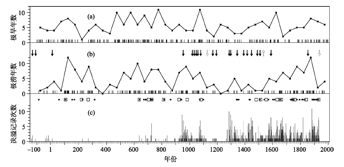
图3. 过去2000年黄河中下游的极端旱涝事件(引自文献[45],据新查阅资料补充修订)与下游干流决溢事件变化
(a)每50年的极端干旱发生年数(点粗线)及具体发生年份(下方短竖线);(b)每50年的极端雨涝发生年数(点粗线)及具体发生年份(下方短竖线),其上方箭头意义同图2用于对比;(c)历史文献记载的大范围特大(方块)/大(小花)洪灾发生年[22]和下游河段决溢次数(下方竖线)[51]
|
Figure 3. Changes of the occurrences of extreme droughts and floods in the middle-lower reaches of the Yellow River and the events of dyke breaching and over-flowing.
(a) The frequency (dot-bold line) per 50 year and the years (vertical line in the bottom) for extreme drought. (b) Same as (a), but for extreme flood. Arrows in the top are the same as Figure 2. (c) The frequency for the events of dyke breaching and over-flowing (vertical line)[51], and the years with very large (marked as white square) and large (black flower) scale devastating flood events recorded in the historical documents[22]
|
|
 |
|
|