|
过去2000年黄河中下游气候与土地覆被变化的若干特征
|
|
郑景云1,4, 文彦君2,3, 方修琦3
|
|
Changes of climate and land cover in the middle and lower reaches of the Yellow River over the past 2000 years
|
ZHENG Jingyun 1,4, WEN Yanjun 2,3, FANG Xiuqi 3
|
|
|
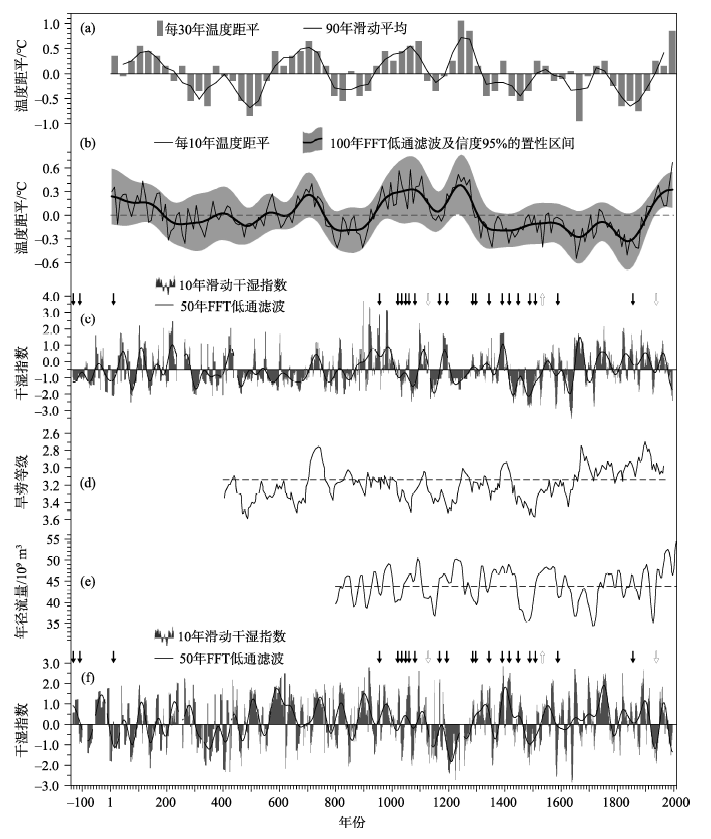
图2. 过去2000年黄河中下游气候变化序列及改道事件发生年份(箭头)
(a)黄河与长江中下游地区冬半年温度[31];(b)全国年均温度[32];(c)黄河中上游地区干湿指数;(d)西安年旱涝等级序列的50年滑动平均[33];(e)黄河中游年径流量的31年低通滤波[34];(f)黄河下游地区干湿指数。(c)和(f)的上方箭头指公元前2世纪中期以来主要改道事件及其发生年(其中1个空心朝上箭头指发生在上游地区的改道,2个空心箭头指下游人为决口造成的改道)
|
Figure 2. The series of climate change in the middle and lower reaches of the Yellow River and the years (marked as arrows) with river avulsion for the past 2000 years.
(a) The winter temperature anomaly (in 30 a resolution) in the middle and lower reaches of the Yellow River and the Yangtze River (bold line: 90-year running mean)[31]. (b) The annual temperature anomaly in China (thin line: 10 a resolution; bold line: the 100-year FFT low-pass filters; gray shading: the 95% confidence intervals)[32]. (c) The dry-wet index for the middle reaches (bold line: the 50-year FFT low-pass filters). (d) The 50-year running mean of drought/flood grade in Xi’an area[33]. (e) The 31-year low-pass filter of tree-ring based annual runoff reconstruction over the middle reaches[34]. (f) Same as plate (c), but for the lower reaches. Down arrows in plates (c) and (f): river avulsion in the lower reaches, in which 2 white marks indicated that induced by human activities; up arrows: river avulsion in the upper reaches
|
|
 |
|
|